
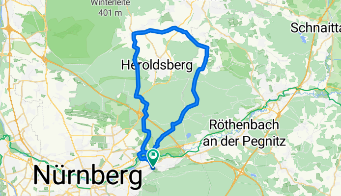
Kalchreuth MTB
A cycling route starting in Schwaig, Bavaria, Germany.
Overview
About this route
None
(cloned from route 597579)
- -:--
- Duration
- 33 km
- Distance
- 226 m
- Ascent
- 226 m
- Descent
- ---
- Avg. speed
- ---
- Max. altitude
Continue with Bikemap
Use, edit, or download this cycling route
You would like to ride Kalchreuth MTB or customize it for your own trip? Here is what you can do with this Bikemap route:
Free features
- Save this route as favorite or in collections
- Copy & plan your own version of this route
- Sync your route with Garmin or Wahoo
Premium features
Free trial for 3 days, or one-time payment. More about Bikemap Premium.
- Navigate this route on iOS & Android
- Export a GPX / KML file of this route
- Create your custom printout (try it for free)
- Download this route for offline navigation
Discover more Premium features.
Get Bikemap PremiumFrom our community
Other popular routes starting in Schwaig
 Nürnberg 01
- Distance
- 51.7 km
- Ascent
- 212 m
- Descent
- 212 m
- Location
- Schwaig, Bavaria, Germany
 Schwaig - Osternohe - Hormersdorf - Hersbruck - Schwaig
- Distance
- 63.9 km
- Ascent
- 432 m
- Descent
- 432 m
- Location
- Schwaig, Bavaria, Germany
 Hersbrucker und Fränkische ADFC 6.7.14
- Distance
- 146.8 km
- Ascent
- 1,184 m
- Descent
- 1,174 m
- Location
- Schwaig, Bavaria, Germany
 Glatzenstein
- Distance
- 52.7 km
- Ascent
- 637 m
- Descent
- 642 m
- Location
- Schwaig, Bavaria, Germany
 Tiergarten Genußrunde 20130925
- Distance
- 7.2 km
- Ascent
- 54 m
- Descent
- 114 m
- Location
- Schwaig, Bavaria, Germany
 5 Brügglersweg - Trailrunde- Tiergarten
- Distance
- 32.7 km
- Ascent
- 189 m
- Descent
- 189 m
- Location
- Schwaig, Bavaria, Germany
 Schöne Runde
- Distance
- 32.2 km
- Ascent
- 281 m
- Descent
- 281 m
- Location
- Schwaig, Bavaria, Germany
 Der hügelige Osten ADFC 6.7.13
- Distance
- 115.9 km
- Ascent
- 898 m
- Descent
- 889 m
- Location
- Schwaig, Bavaria, Germany
Open it in the app