

Utg - OStB Tag 2
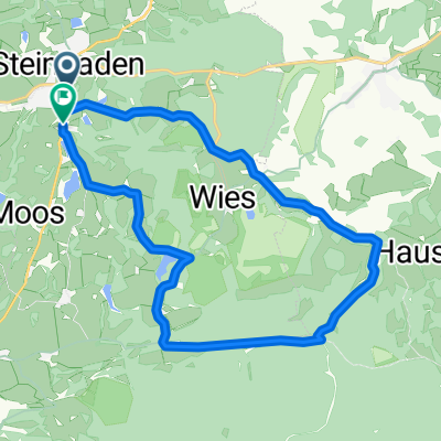
A cycling route starting in Steingaden, Bavaria, Germany.
Overview
About this route
Wieskirche via Bad Kohlgrub, Uffing to Murnau/Seehausen, Am Fügsee 2 Pension Andre
- -:--
- Duration
- 36.7 km
- Distance
- 318 m
- Ascent
- 489 m
- Descent
- ---
- Avg. speed
- ---
- Max. altitude

Route quality
Waytypes & surfaces along the route
Waytypes
Quiet road
25.3 km
(69 %)
Track
6.2 km
(17 %)
Surfaces
Paved
29.7 km
(81 %)
Unpaved
4.8 km
(13 %)
Asphalt
29 km
(79 %)
Gravel
2.6 km
(7 %)
Continue with Bikemap
Use, edit, or download this cycling route
You would like to ride Utg - OStB Tag 2 or customize it for your own trip? Here is what you can do with this Bikemap route:
Free features
- Save this route as favorite or in collections
- Copy & plan your own version of this route
- Sync your route with Garmin or Wahoo
Premium features
Free trial for 3 days, or one-time payment. More about Bikemap Premium.
- Navigate this route on iOS & Android
- Export a GPX / KML file of this route
- Create your custom printout (try it for free)
- Download this route for offline navigation
Discover more Premium features.
Get Bikemap PremiumFrom our community
Other popular routes starting in Steingaden
 Tour 3 Königsstraße
- Distance
- 69.6 km
- Ascent
- 1,060 m
- Descent
- 1,061 m
- Location
- Steingaden, Bavaria, Germany
 Steingaden - Tutzing
- Distance
- 67.8 km
- Ascent
- 619 m
- Descent
- 781 m
- Location
- Steingaden, Bavaria, Germany
 Wies 1, Steingaden nach Weidachstraße 74, Füssen
- Distance
- 30.6 km
- Ascent
- 1,119 m
- Descent
- 1,195 m
- Location
- Steingaden, Bavaria, Germany
 Steingaden Saulgrub
- Distance
- 41.5 km
- Ascent
- 409 m
- Descent
- 409 m
- Location
- Steingaden, Bavaria, Germany
 Urspring-Roßhaupten-Seeg-Hopfen-Roßhaupten-Urspring
- Distance
- 69 km
- Ascent
- 438 m
- Descent
- 437 m
- Location
- Steingaden, Bavaria, Germany
 Wieskirchenregion kurz
- Distance
- 17.7 km
- Ascent
- 209 m
- Descent
- 191 m
- Location
- Steingaden, Bavaria, Germany
 Fuessen
- Distance
- 60.5 km
- Ascent
- 307 m
- Descent
- 310 m
- Location
- Steingaden, Bavaria, Germany
 Tour 2020 Etappe 3
- Distance
- 120 km
- Ascent
- 261 m
- Descent
- 558 m
- Location
- Steingaden, Bavaria, Germany
Open it in the app