

Stoißeralm
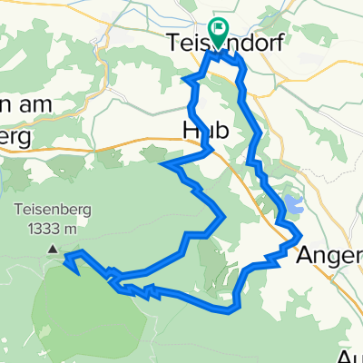
A cycling route starting in Teisendorf, Bavaria, Germany.
Overview
About this route
On forest tracks, steep at the end
- -:--
- Duration
- 26.4 km
- Distance
- 795 m
- Ascent
- 795 m
- Descent
- ---
- Avg. speed
- ---
- Max. altitude
Route quality
Waytypes & surfaces along the route
Waytypes
Track
17.1 km
(65 %)
Quiet road
6.6 km
(25 %)
Surfaces
Paved
6.9 km
(26 %)
Unpaved
17.7 km
(67 %)
Gravel
15.3 km
(58 %)
Asphalt
6.9 km
(26 %)
Route highlights
Points of interest along the route
Point of interest after 13.6 km
Sturz T
Continue with Bikemap
Use, edit, or download this cycling route
You would like to ride Stoißeralm or customize it for your own trip? Here is what you can do with this Bikemap route:
Free features
- Save this route as favorite or in collections
- Copy & plan your own version of this route
- Sync your route with Garmin or Wahoo
Premium features
Free trial for 3 days, or one-time payment. More about Bikemap Premium.
- Navigate this route on iOS & Android
- Export a GPX / KML file of this route
- Create your custom printout (try it for free)
- Download this route for offline navigation
Discover more Premium features.
Get Bikemap PremiumFrom our community
Other popular routes starting in Teisendorf
 Tsdf Traunstein Teisenberg
- Distance
- 34.7 km
- Ascent
- 363 m
- Descent
- 363 m
- Location
- Teisendorf, Bavaria, Germany
 2016_2_Königssee - Bodensee (Teisendorf - Aschau)
- Distance
- 72 km
- Ascent
- 674 m
- Descent
- 574 m
- Location
- Teisendorf, Bavaria, Germany
 Stoißeralm
- Distance
- 26.4 km
- Ascent
- 795 m
- Descent
- 795 m
- Location
- Teisendorf, Bavaria, Germany
 Traunsteinrunde
- Distance
- 38.9 km
- Ascent
- 409 m
- Descent
- 409 m
- Location
- Teisendorf, Bavaria, Germany
 Abtsdorfer See
- Distance
- 44.2 km
- Ascent
- 324 m
- Descent
- 327 m
- Location
- Teisendorf, Bavaria, Germany
 2012 Teisendorf-Schönau/Königssee
- Distance
- 48.8 km
- Ascent
- 446 m
- Descent
- 335 m
- Location
- Teisendorf, Bavaria, Germany
 Stoißeralm
- Distance
- 26.3 km
- Ascent
- 1,098 m
- Descent
- 993 m
- Location
- Teisendorf, Bavaria, Germany
 Ibm-Runde
- Distance
- 109.6 km
- Ascent
- 1,193 m
- Descent
- 1,227 m
- Location
- Teisendorf, Bavaria, Germany
Open it in the app