

20150514_110345.gpx
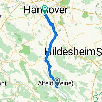
A cycling route starting in Alfeld, Lower Saxony, Germany.
Overview
About this route
TEASI track
- -:--
- Duration
- 7.2 km
- Distance
- 281 m
- Ascent
- 281 m
- Descent
- ---
- Avg. speed
- ---
- Max. altitude
Route highlights
Points of interest along the route
Point of interest after 3.4 km
ADAMISHUETTE
Continue with Bikemap
Use, edit, or download this cycling route
You would like to ride 20150514_110345.gpx or customize it for your own trip? Here is what you can do with this Bikemap route:
Free features
- Save this route as favorite or in collections
- Copy & plan your own version of this route
- Sync your route with Garmin or Wahoo
Premium features
Free trial for 3 days, or one-time payment. More about Bikemap Premium.
- Navigate this route on iOS & Android
- Export a GPX / KML file of this route
- Create your custom printout (try it for free)
- Download this route for offline navigation
Discover more Premium features.
Get Bikemap PremiumFrom our community
Other popular routes starting in Alfeld
 Vergleich der Strecken Alfeld - Buchholz in der Nordheide
- Distance
- 374.1 km
- Ascent
- 280 m
- Descent
- 304 m
- Location
- Alfeld, Lower Saxony, Germany
 Alfeld-Hildesh. 52
- Distance
- 52.2 km
- Ascent
- 159 m
- Descent
- 159 m
- Location
- Alfeld, Lower Saxony, Germany
 2020 - Leine - Tag 2 - Röllinghausen - Banteln
- Distance
- 15.9 km
- Ascent
- 56 m
- Descent
- 62 m
- Location
- Alfeld, Lower Saxony, Germany
 Fahrrad Tour von Alfeld nach Winzenburg
- Distance
- 12.2 km
- Ascent
- 146 m
- Descent
- 131 m
- Location
- Alfeld, Lower Saxony, Germany
 Absolutes Flachland
- Distance
- 56.3 km
- Ascent
- 138 m
- Descent
- 169 m
- Location
- Alfeld, Lower Saxony, Germany
 6 Alfeld H
- Distance
- 63.1 km
- Ascent
- 145 m
- Descent
- 184 m
- Location
- Alfeld, Lower Saxony, Germany
 Alfeld - Buchholz in der Nordheide
- Distance
- 188.9 km
- Ascent
- 250 m
- Descent
- 274 m
- Location
- Alfeld, Lower Saxony, Germany
 Alfeld Gronau Friedhof
- Distance
- 14.9 km
- Ascent
- 41 m
- Descent
- 49 m
- Location
- Alfeld, Lower Saxony, Germany
Open it in the app