

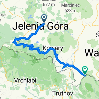
zabobrze podgórzyn borowice sosnówka staniszów obwodnica droga rowerowa krzyż meta
A cycling route starting in Jeżów Sudecki, Lower Silesian Voivodeship, Poland.
Overview
About this route
Zabobrze Podgórzyn Borowice Sosnówka Staniszów bypass bike path cross finish
- -:--
- Duration
- 44.4 km
- Distance
- 465 m
- Ascent
- 465 m
- Descent
- ---
- Avg. speed
- ---
- Max. altitude

Route quality
Waytypes & surfaces along the route
Waytypes
Road
30.6 km
(69 %)
Path
6.7 km
(15 %)
Surfaces
Paved
39.1 km
(88 %)
Asphalt
37.7 km
(85 %)
Paved (undefined)
0.9 km
(2 %)
Route highlights
Points of interest along the route
Point of interest after 0.7 km
salon rowerowy www.salon-rowerowy.pl
Continue with Bikemap
Use, edit, or download this cycling route
You would like to ride zabobrze podgórzyn borowice sosnówka staniszów obwodnica droga rowerowa krzyż meta or customize it for your own trip? Here is what you can do with this Bikemap route:
Free features
- Save this route as favorite or in collections
- Copy & plan your own version of this route
- Sync your route with Garmin or Wahoo
Premium features
Free trial for 3 days, or one-time payment. More about Bikemap Premium.
- Navigate this route on iOS & Android
- Export a GPX / KML file of this route
- Create your custom printout (try it for free)
- Download this route for offline navigation
Discover more Premium features.
Get Bikemap PremiumFrom our community
Other popular routes starting in Jeżów Sudecki
 Karkonosze i Góry Izerskie
- Distance
- 111.4 km
- Ascent
- 1,132 m
- Descent
- 1,062 m
- Location
- Jeżów Sudecki, Lower Silesian Voivodeship, Poland
 Karkonosze
- Distance
- 93.4 km
- Ascent
- 1,671 m
- Descent
- 1,456 m
- Location
- Jeżów Sudecki, Lower Silesian Voivodeship, Poland
 Jelenia - Kopaniec - Rozdroże - Szklarska - Piechowice - JG
- Distance
- 75.6 km
- Ascent
- 837 m
- Descent
- 837 m
- Location
- Jeżów Sudecki, Lower Silesian Voivodeship, Poland
 Jelenia Góra - Tanvald (CZK)
- Distance
- 99.8 km
- Ascent
- 1,301 m
- Descent
- 1,300 m
- Location
- Jeżów Sudecki, Lower Silesian Voivodeship, Poland
 Pętla Jelenia Góra - Michałowice - Zachełmie - Przesieka - Borowice - Sosnówka - Staniszów
- Distance
- 62.8 km
- Ascent
- 881 m
- Descent
- 880 m
- Location
- Jeżów Sudecki, Lower Silesian Voivodeship, Poland
 JG-Zapora_Wojciechow_Barcinek_JG
- Distance
- 47.1 km
- Ascent
- 374 m
- Descent
- 377 m
- Location
- Jeżów Sudecki, Lower Silesian Voivodeship, Poland
 Dzień 3
- Distance
- 67.6 km
- Ascent
- 492 m
- Descent
- 368 m
- Location
- Jeżów Sudecki, Lower Silesian Voivodeship, Poland
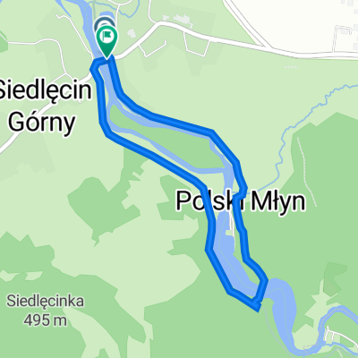 Siedlęcin - Perła Zachodu
- Distance
- 3.2 km
- Ascent
- 86 m
- Descent
- 86 m
- Location
- Jeżów Sudecki, Lower Silesian Voivodeship, Poland
Open it in the app