

May 17, 2015, 3:28 PM
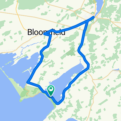
A cycling route starting in Prince Edward, Ontario, Canada.
Overview
About this route
2015-05-17, 3:28 PM
- -:--
- Duration
- 38.3 km
- Distance
- 110 m
- Ascent
- 109 m
- Descent
- ---
- Avg. speed
- ---
- Max. altitude
Continue with Bikemap
Use, edit, or download this cycling route
You would like to ride May 17, 2015, 3:28 PM or customize it for your own trip? Here is what you can do with this Bikemap route:
Free features
- Save this route as favorite or in collections
- Copy & plan your own version of this route
- Sync your route with Garmin or Wahoo
Premium features
Free trial for 3 days, or one-time payment. More about Bikemap Premium.
- Navigate this route on iOS & Android
- Export a GPX / KML file of this route
- Create your custom printout (try it for free)
- Download this route for offline navigation
Discover more Premium features.
Get Bikemap PremiumFrom our community
Other popular routes starting in Prince Edward
 swamp college to church camp
- Distance
- 33.4 km
- Ascent
- 62 m
- Descent
- 60 m
- Location
- Prince Edward, Ontario, Canada
 Bloomfield to County Cider Factory and back
- Distance
- 65.7 km
- Ascent
- 261 m
- Descent
- 261 m
- Location
- Prince Edward, Ontario, Canada
 Wellington Brighton Wellington
- Distance
- 90.9 km
- Ascent
- 204 m
- Descent
- 205 m
- Location
- Prince Edward, Ontario, Canada
 Recreational Trails Map - Gateway Country - Route 5
- Distance
- 40.4 km
- Ascent
- 107 m
- Descent
- 109 m
- Location
- Prince Edward, Ontario, Canada
 randonnée de vacance
- Distance
- 60.7 km
- Ascent
- 241 m
- Descent
- 238 m
- Location
- Prince Edward, Ontario, Canada
 canada day 100k
- Distance
- 104.5 km
- Ascent
- 126 m
- Descent
- 126 m
- Location
- Prince Edward, Ontario, Canada
 Corto fondo
- Distance
- 47.2 km
- Ascent
- 111 m
- Descent
- 111 m
- Location
- Prince Edward, Ontario, Canada
 classic western wine route
- Distance
- 59.9 km
- Ascent
- 76 m
- Descent
- 76 m
- Location
- Prince Edward, Ontario, Canada
Open it in the app