

Vilsalpsee
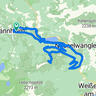
A cycling route starting in Tannheim, Tyrol, Austria.
Overview
About this route
Beschreibung Da das Gebiet rund um den Vilsalpsee bereits seit über 50 Jahren als Naturschutzgebiet ausgewiesen ist und gleichzeitig Natura 2000-Gebiet ist, verbirgt diese Wanderung besonders reizvolles. Start- und auch Endpunkt ist das Gasthaus direkt am Vilsalpsee. Gegen den Uhrzeigersinn, vorbei an der Fischerstube über die Brücke, geht es Richtung Weltlingalpe. Der Schotterweg, breit und gut zu begehen, verläuft auf dieser Seite des Sees genau am Ufer. Am hinteren Ende des Sees ist die bewirtschaftete Vilsalpe. Zurück zum Ausgangspunkt geht es auf dem selben Weg, da der Weg auf der gegenüberliegenden Seite wegen Steinschlag momentan gesperrt ist.. Schwierigkeit: leicht Strecke: 4,0 km Aufstieg: 111 m Abstieg: 111 m Dauer: 1:01 h Niedrigster Punkt: 1166 m Höchster Punkt: 1204 m
- -:--
- Duration
- 4 km
- Distance
- 132 m
- Ascent
- 132 m
- Descent
- ---
- Avg. speed
- ---
- Max. altitude
Continue with Bikemap
Use, edit, or download this cycling route
You would like to ride Vilsalpsee or customize it for your own trip? Here is what you can do with this Bikemap route:
Free features
- Save this route as favorite or in collections
- Copy & plan your own version of this route
- Sync your route with Garmin or Wahoo
Premium features
Free trial for 3 days, or one-time payment. More about Bikemap Premium.
- Navigate this route on iOS & Android
- Export a GPX / KML file of this route
- Create your custom printout (try it for free)
- Download this route for offline navigation
Discover more Premium features.
Get Bikemap PremiumFrom our community
Other popular routes starting in Tannheim
 Vorarlbergrunde
- Distance
- 166.2 km
- Ascent
- 2,190 m
- Descent
- 2,190 m
- Location
- Tannheim, Tyrol, Austria
 Tannheim-Haldensee
- Distance
- 35.6 km
- Ascent
- 726 m
- Descent
- 726 m
- Location
- Tannheim, Tyrol, Austria
 Allgäu-Runde mittel
- Distance
- 124.3 km
- Ascent
- 820 m
- Descent
- 821 m
- Location
- Tannheim, Tyrol, Austria
 Höf 1, Tannheim nach Tannheimer Straße
- Distance
- 75.5 km
- Ascent
- 1,367 m
- Descent
- 1,344 m
- Location
- Tannheim, Tyrol, Austria
 Tannheim Jungholz Tannheim
- Distance
- 40.2 km
- Ascent
- 459 m
- Descent
- 460 m
- Location
- Tannheim, Tyrol, Austria
 Tannheim-Nesselwaengle-Vilalbsee
- Distance
- 41.8 km
- Ascent
- 1,350 m
- Descent
- 1,350 m
- Location
- Tannheim, Tyrol, Austria
 Tannheimer Tal - Radmarathon
- Distance
- 225.8 km
- Ascent
- 2,320 m
- Descent
- 2,321 m
- Location
- Tannheim, Tyrol, Austria
 Tour 2013 Namlosrunde Schwierigkeitsgrad mittel
- Distance
- 74.5 km
- Ascent
- 947 m
- Descent
- 951 m
- Location
- Tannheim, Tyrol, Austria
Open it in the app