

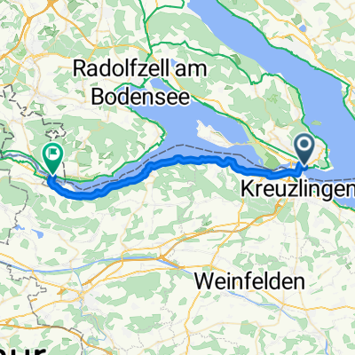
Alpenpanorama-Route (Konstanz-Appenzell)
A cycling route starting in Kreuzlingen, Thurgau, Switzerland.
Overview
About this route
Traumhafte Tour durchs grüne Appenzeller-Land. Den Säntis erst von der Ferne, dann von unmittelbarer Nähe im Blick. Von Wattwil bis Au (Büriswilen) der ausgeschilderten schweizer National-Route 4 (Alpenpanorama-Route) folgen.
- -:--
- Duration
- 188.7 km
- Distance
- 3,096 m
- Ascent
- 3,084 m
- Descent
- ---
- Avg. speed
- 1,071 m
- Max. altitude
Route quality
Waytypes & surfaces along the route
Waytypes
Busy road
71.6 km
(38 %)
Road
48 km
(25 %)
Surfaces
Paved
157.3 km
(83 %)
Unpaved
1 km
(<1 %)
Asphalt
152.9 km
(81 %)
Paving stones
2.2 km
(1 %)
Route highlights
Points of interest along the route
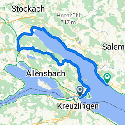
Point of interest after 47.1 km
erste Brotzeit-Pause
Point of interest after 63.9 km
Kaffee-Pause
Point of interest after 72.2 km
höchster Punkt der Tour: 1068m
Point of interest after 92.2 km
Günstige Unterkunft in Weissbad in der Bäckerei/Gasthaus Lohssmühle (Touristenlager 30,- CHF)
Point of interest after 154.6 km
Mittagessen am Yachthafen
Point of interest after 183.5 km
Therme Konstanz: ein wohlverdienter Abschluss der 2-Tages-Tour
Continue with Bikemap
Use, edit, or download this cycling route
You would like to ride Alpenpanorama-Route (Konstanz-Appenzell) or customize it for your own trip? Here is what you can do with this Bikemap route:
Free features
- Save this route as favorite or in collections
- Copy & plan your own version of this route
- Split it into stages to create a multi-day tour
- Sync your route with Garmin or Wahoo
Premium features
Free trial for 3 days, or one-time payment. More about Bikemap Premium.
- Navigate this route on iOS & Android
- Export a GPX / KML file of this route
- Create your custom printout (try it for free)
- Download this route for offline navigation
Discover more Premium features.
Get Bikemap PremiumFrom our community
Other popular routes starting in Kreuzlingen
 Bodenseeradweg ab Friedrichshafen
- Distance
- 255.9 km
- Ascent
- 268 m
- Descent
- 268 m
- Location
- Kreuzlingen, Thurgau, Switzerland
 Samstagmittagrunde
- Distance
- 46.3 km
- Ascent
- 288 m
- Descent
- 291 m
- Location
- Kreuzlingen, Thurgau, Switzerland
 Tour 3/34 km / Insel-Reichenau
- Distance
- 33.9 km
- Ascent
- 134 m
- Descent
- 133 m
- Location
- Kreuzlingen, Thurgau, Switzerland
 D 251 Konstanz - Stein am Rhein
- Distance
- 29.5 km
- Ascent
- 75 m
- Descent
- 75 m
- Location
- Kreuzlingen, Thurgau, Switzerland
 Von Konstanz um den Überlinger See nach Meersburg (Bodensee)
- Distance
- 64.9 km
- Ascent
- 318 m
- Descent
- 316 m
- Location
- Kreuzlingen, Thurgau, Switzerland
 Wäldi-Runde
- Distance
- 21.4 km
- Ascent
- 237 m
- Descent
- 207 m
- Location
- Kreuzlingen, Thurgau, Switzerland
 Abendrunde Thurgau
- Distance
- 40 km
- Ascent
- 252 m
- Descent
- 253 m
- Location
- Kreuzlingen, Thurgau, Switzerland
 Bodensee 1
- Distance
- 76.1 km
- Ascent
- 449 m
- Descent
- 418 m
- Location
- Kreuzlingen, Thurgau, Switzerland
Open it in the app