Rund um den Truppenübugsplatz Hohenfels
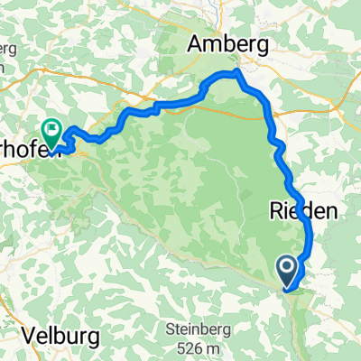
A cycling route starting in Schmidmühlen, Bavaria, Germany.
Overview
About this route
Um den Truppenübungsplatz und durch das schöne Lauterachtal
(cloned from route 2243243)- -:--
- Duration
- 80.2 km
- Distance
- 608 m
- Ascent
- 608 m
- Descent
- ---
- Avg. speed
- ---
- Max. altitude
Route quality
Waytypes & surfaces along the route
Waytypes
Track
31 km
(39 %)
Quiet road
16.2 km
(20 %)
Surfaces
Paved
62 km
(77 %)
Unpaved
5.6 km
(7 %)
Asphalt
50.8 km
(63 %)
Paved (undefined)
11.2 km
(14 %)
Continue with Bikemap
Use, edit, or download this cycling route
You would like to ride Rund um den Truppenübugsplatz Hohenfels or customize it for your own trip? Here is what you can do with this Bikemap route:
Free features
- Save this route as favorite or in collections
- Copy & plan your own version of this route
- Split it into stages to create a multi-day tour
- Sync your route with Garmin or Wahoo
Premium features
Free trial for 3 days, or one-time payment. More about Bikemap Premium.
- Navigate this route on iOS & Android
- Export a GPX / KML file of this route
- Create your custom printout (try it for free)
- Download this route for offline navigation
Discover more Premium features.
Get Bikemap PremiumFrom our community
Other popular routes starting in Schmidmühlen
- Bahnhofstraße nach St.-Martin-Straße
- Distance
- 44.4 km
- Ascent
- 426 m
- Descent
- 376 m
- Location
- Schmidmühlen, Bavaria, Germany
- Rund um den Truppenübugsplatz Hohenfels
- Distance
- 80.1 km
- Ascent
- 545 m
- Descent
- 545 m
- Location
- Schmidmühlen, Bavaria, Germany
- Rund um den Truppenübungsplatz Hohenfels
- Distance
- 84.7 km
- Ascent
- 375 m
- Descent
- 375 m
- Location
- Schmidmühlen, Bavaria, Germany
- W-P3: Schmidmühlen - Paulushofen 71,6km 526hm
- Distance
- 71.6 km
- Ascent
- 526 m
- Descent
- 376 m
- Location
- Schmidmühlen, Bavaria, Germany
- Hohenfels_21092019
- Distance
- 72.9 km
- Ascent
- 452 m
- Descent
- 452 m
- Location
- Schmidmühlen, Bavaria, Germany
- Rund um den Truppenübugsplatz Hohenfels
- Distance
- 80.2 km
- Ascent
- 608 m
- Descent
- 608 m
- Location
- Schmidmühlen, Bavaria, Germany
- 21.05.02
- Distance
- 49.5 km
- Ascent
- 389 m
- Descent
- 387 m
- Location
- Schmidmühlen, Bavaria, Germany
- Wacholderwanderweg durchs Lauterachtal (von Schmidmühlen nach Kastl)
- Distance
- 30.2 km
- Ascent
- 851 m
- Descent
- 760 m
- Location
- Schmidmühlen, Bavaria, Germany
Open it in the app