

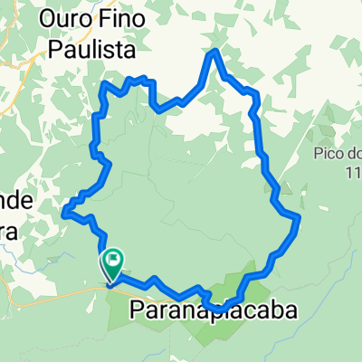
Paranapiacaba
A cycling route starting in Rio Grande da Serra, São Paulo, Brazil.
Overview
About this route
A little trail that always goes straight. It passes through some very nice sections of denser forest. And occasionally, quite a bit of mud. Out and back on the same stretch. Only the outward journey is marked.
- -:--
- Duration
- 12.1 km
- Distance
- 364 m
- Ascent
- 355 m
- Descent
- ---
- Avg. speed
- 946 m
- Max. altitude
Route quality
Waytypes & surfaces along the route
Waytypes
Quiet road
7 km
(58 %)
Road
5.1 km
(42 %)
Surfaces
Unpaved
11.5 km
(95 %)
Ground
11.3 km
(93 %)
Unpaved (undefined)
0.2 km
(2 %)
Undefined
0.6 km
(5 %)
Route highlights
Points of interest along the route

Point of interest after 0 km
Bar da Tia Zilda. Bom ponto de encontro tanto antes quanto depois da trilha!
Point of interest after 0.9 km
Início do trecho de terra.
Point of interest after 3.3 km

Point of interest after 4.2 km
Taquarussu. Bom local para descansar e pega água.
Continue with Bikemap
Use, edit, or download this cycling route
You would like to ride Paranapiacaba or customize it for your own trip? Here is what you can do with this Bikemap route:
Free features
- Save this route as favorite or in collections
- Copy & plan your own version of this route
- Sync your route with Garmin or Wahoo
Premium features
Free trial for 3 days, or one-time payment. More about Bikemap Premium.
- Navigate this route on iOS & Android
- Export a GPX / KML file of this route
- Create your custom printout (try it for free)
- Download this route for offline navigation
Discover more Premium features.
Get Bikemap PremiumFrom our community
Other popular routes starting in Rio Grande da Serra
 Trilha em Paranapiacaba
- Distance
- 34.2 km
- Ascent
- 406 m
- Descent
- 406 m
- Location
- Rio Grande da Serra, São Paulo, Brazil
 CAMINHO DO SAL (Mogi das Cruzes, Paranapiacaba, Riacho Grande)
- Distance
- 68.2 km
- Ascent
- 494 m
- Descent
- 522 m
- Location
- Rio Grande da Serra, São Paulo, Brazil
 Paranapiacaba - Quatinga via Taquaruçu
- Distance
- 38.5 km
- Ascent
- 446 m
- Descent
- 452 m
- Location
- Rio Grande da Serra, São Paulo, Brazil
 Paranapiacaba x Magic City x Taquarussu x Paranapiacaba
- Distance
- 41.3 km
- Ascent
- 619 m
- Descent
- 617 m
- Location
- Rio Grande da Serra, São Paulo, Brazil
 Rio Grande da Serra-Paranapiacaba
- Distance
- 12.9 km
- Ascent
- 277 m
- Descent
- 200 m
- Location
- Rio Grande da Serra, São Paulo, Brazil
 Terra 56KM Paranapiacaba
- Distance
- 58 km
- Ascent
- 546 m
- Descent
- 548 m
- Location
- Rio Grande da Serra, São Paulo, Brazil
 Paranapiacaba
- Distance
- 33 km
- Ascent
- 423 m
- Descent
- 424 m
- Location
- Rio Grande da Serra, São Paulo, Brazil
 Paranapiacaba
- Distance
- 12.1 km
- Ascent
- 364 m
- Descent
- 355 m
- Location
- Rio Grande da Serra, São Paulo, Brazil
Open it in the app