

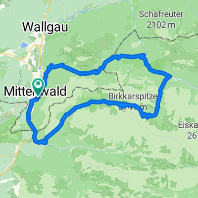
Von Mittenwald durch das Tal der Leutascher Ache
A cycling route starting in Mittenwald, Bavaria, Germany.
Overview
About this route
Bequeme Radtour Mittelwald > Scharnitz > Sattelsteig > Durch den Boden > Weidach > Kirchplatzl > Weg 33 Richtung Klammer > Plaik > Fahrweg entlang der Leutascher Ache > Igelsee > ab hier etwas steilerer Anstieg Knappensteig. Wer in der Ehrwalder Alm einkehren will, muss ca. 100 m bergab und mit vollem Bauch wieder bergauf.
- -:--
- Duration
- 66.8 km
- Distance
- 1,036 m
- Ascent
- 939 m
- Descent
- ---
- Avg. speed
- 1,601 m
- Max. altitude
Route quality
Waytypes & surfaces along the route
Waytypes
Track
32.7 km
(49 %)
Road
12 km
(18 %)
Surfaces
Paved
32.1 km
(48 %)
Unpaved
31.4 km
(47 %)
Asphalt
32.1 km
(48 %)
Gravel
24 km
(36 %)
Continue with Bikemap
Use, edit, or download this cycling route
You would like to ride Von Mittenwald durch das Tal der Leutascher Ache or customize it for your own trip? Here is what you can do with this Bikemap route:
Free features
- Save this route as favorite or in collections
- Copy & plan your own version of this route
- Sync your route with Garmin or Wahoo
Premium features
Free trial for 3 days, or one-time payment. More about Bikemap Premium.
- Navigate this route on iOS & Android
- Export a GPX / KML file of this route
- Create your custom printout (try it for free)
- Download this route for offline navigation
Discover more Premium features.
Get Bikemap PremiumFrom our community
Other popular routes starting in Mittenwald
 -> Ferein Alm -> Karwendelhaus
- Distance
- 67.7 km
- Ascent
- 1,579 m
- Descent
- 1,576 m
- Location
- Mittenwald, Bavaria, Germany
 Karwendelrunde light - Mittenwald - Scharnitz - Karwendelhaus - Hinterriss - Vorderriss - Wallgau
- Distance
- 75.5 km
- Ascent
- 1,530 m
- Descent
- 1,530 m
- Location
- Mittenwald, Bavaria, Germany
 Soiern-Runde
- Distance
- 48.6 km
- Ascent
- 945 m
- Descent
- 945 m
- Location
- Mittenwald, Bavaria, Germany
 Karwendelrunde
- Distance
- 65 km
- Ascent
- 1,582 m
- Descent
- 1,572 m
- Location
- Mittenwald, Bavaria, Germany
 Mittenwald_München
- Distance
- 115.5 km
- Ascent
- 214 m
- Descent
- 603 m
- Location
- Mittenwald, Bavaria, Germany
 Letzte Etappe Ulm-Gardasee-Ulm
- Distance
- 214.9 km
- Ascent
- 1,305 m
- Descent
- 1,666 m
- Location
- Mittenwald, Bavaria, Germany
 Mittenwald - Riva
- Distance
- 389.2 km
- Ascent
- 7,671 m
- Descent
- 8,511 m
- Location
- Mittenwald, Bavaria, Germany
 Mittenwald -St.Moritz(CH)
- Distance
- 204.3 km
- Ascent
- 2,276 m
- Descent
- 1,364 m
- Location
- Mittenwald, Bavaria, Germany
Open it in the app