
saint jean du puy
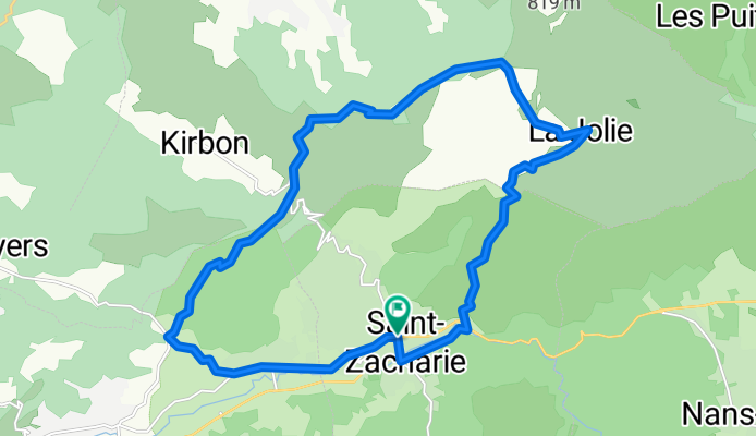
A cycling route starting in Saint-Zacharie, Provence-Alpes-Côte d'Azur Region, France.
Overview
About this route
parcour numero 39 du vtopo BDR
(cloned from route 2836213)- -:--
- Duration
- 22.7 km
- Distance
- 577 m
- Ascent
- 577 m
- Descent
- ---
- Avg. speed
- ---
- Max. altitude
Route highlights
Points of interest along the route
Point of interest after 4.4 km
frontiere var bouche du rhone
Continue with Bikemap
Use, edit, or download this cycling route
You would like to ride saint jean du puy or customize it for your own trip? Here is what you can do with this Bikemap route:
Free features
- Save this route as favorite or in collections
- Copy & plan your own version of this route
- Sync your route with Garmin or Wahoo
Premium features
Free trial for 3 days, or one-time payment. More about Bikemap Premium.
- Navigate this route on iOS & Android
- Export a GPX / KML file of this route
- Create your custom printout (try it for free)
- Download this route for offline navigation
Discover more Premium features.
Get Bikemap PremiumFrom our community
Other popular routes starting in Saint-Zacharie
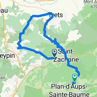
 Massif de La Sainte Baume
- Distance
- 32.6 km
- Ascent
- 541 m
- Descent
- 541 m
- Location
- Saint-Zacharie, Provence-Alpes-Côte d'Azur Region, France
 Les souces de l huvaune
- Distance
- 18.7 km
- Ascent
- 249 m
- Descent
- 249 m
- Location
- Saint-Zacharie, Provence-Alpes-Côte d'Azur Region, France
 Tour du Garlaban
- Distance
- 61.2 km
- Ascent
- 569 m
- Descent
- 569 m
- Location
- Saint-Zacharie, Provence-Alpes-Côte d'Azur Region, France
 saint-zacharie la ciotat
- Distance
- 50.5 km
- Ascent
- 658 m
- Descent
- 972 m
- Location
- Saint-Zacharie, Provence-Alpes-Côte d'Azur Region, France
 De Rue des Émailleurs à Rue des Vents Bis
- Distance
- 118.1 km
- Ascent
- 1,123 m
- Descent
- 1,359 m
- Location
- Saint-Zacharie, Provence-Alpes-Côte d'Azur Region, France
 a la recherche des sources de l'huveaune
- Distance
- 13.4 km
- Ascent
- 521 m
- Descent
- 301 m
- Location
- Saint-Zacharie, Provence-Alpes-Côte d'Azur Region, France
 saint jean du puy
- Distance
- 22.7 km
- Ascent
- 577 m
- Descent
- 577 m
- Location
- Saint-Zacharie, Provence-Alpes-Côte d'Azur Region, France
 Etape 4 Auriol
- Distance
- 40.3 km
- Ascent
- 887 m
- Descent
- 545 m
- Location
- Saint-Zacharie, Provence-Alpes-Côte d'Azur Region, France
Open it in the app