

Über die Hänge der Müglitz
A cycling route starting in Heidenau, Saxony, Germany.
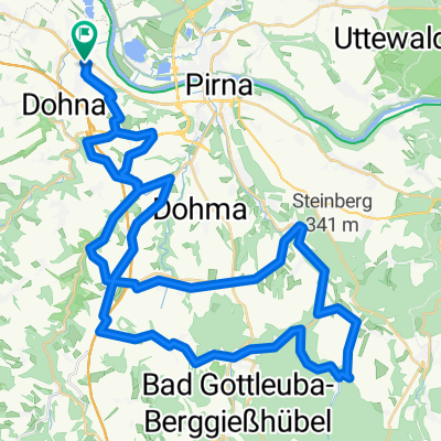
Overview
About this route
Recht anspruchsvolle Strecke mit einigen steilen Anstiegen
- -:--
- Duration
- 80.7 km
- Distance
- 1,498 m
- Ascent
- 1,400 m
- Descent
- ---
- Avg. speed
- 679 m
- Max. altitude
Route quality
Waytypes & surfaces along the route
Waytypes
Road
44.9 km
(56 %)
Busy road
19.4 km
(24 %)
Surfaces
Paved
55.8 km
(69 %)
Unpaved
4.3 km
(5 %)
Asphalt
54.8 km
(68 %)
Ground
2.8 km
(4 %)
Continue with Bikemap
Use, edit, or download this cycling route
You would like to ride Über die Hänge der Müglitz or customize it for your own trip? Here is what you can do with this Bikemap route:
Free features
- Save this route as favorite or in collections
- Copy & plan your own version of this route
- Split it into stages to create a multi-day tour
- Sync your route with Garmin or Wahoo
Premium features
Free trial for 3 days, or one-time payment. More about Bikemap Premium.
- Navigate this route on iOS & Android
- Export a GPX / KML file of this route
- Create your custom printout (try it for free)
- Download this route for offline navigation
Discover more Premium features.
Get Bikemap PremiumFrom our community
Other popular routes starting in Heidenau
 Wehlen - Hocksteinschänke - Stolpen - Hochland
- Distance
- 67.1 km
- Ascent
- 530 m
- Descent
- 375 m
- Location
- Heidenau, Saxony, Germany
 LockwitztalWilischLuchau
- Distance
- 48.3 km
- Ascent
- 809 m
- Descent
- 815 m
- Location
- Heidenau, Saxony, Germany
 Schnelle Ausfahrt vom 28.07.17, 18:38
- Distance
- 7.9 km
- Ascent
- 16 m
- Descent
- 16 m
- Location
- Heidenau, Saxony, Germany
 33. Heidenauer RTF 20.09.2014 - 120 km
- Distance
- 114.6 km
- Ascent
- 900 m
- Descent
- 901 m
- Location
- Heidenau, Saxony, Germany
 Borsberg 013-1226hm
- Distance
- 42.3 km
- Ascent
- 0 m
- Descent
- 0 m
- Location
- Heidenau, Saxony, Germany
 Schönfelder Hochlandtour
- Distance
- 44.2 km
- Ascent
- 331 m
- Descent
- 332 m
- Location
- Heidenau, Saxony, Germany
 Heide-Hochland-Liebethal-Pirna
- Distance
- 59.2 km
- Ascent
- 236 m
- Descent
- 234 m
- Location
- Heidenau, Saxony, Germany
 33. Heidenauer RTF 20.09.2014 - 60km -
- Distance
- 56.2 km
- Ascent
- 655 m
- Descent
- 656 m
- Location
- Heidenau, Saxony, Germany
Open it in the app