
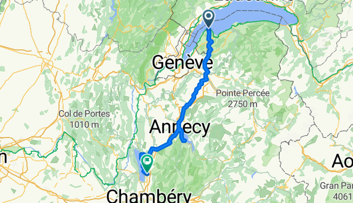
GenferSee(F) - LacAnnecy - LacBourget
A cycling route starting in Messery, Auvergne-Rhône-Alpes, France.
Overview
About this route
Lake Geneva (F) - Lake Annecy - Lake Bourget
- -:--
- Duration
- 140.6 km
- Distance
- 1,412 m
- Ascent
- 1,559 m
- Descent
- ---
- Avg. speed
- ---
- Max. altitude
Route quality
Waytypes & surfaces along the route
Waytypes
Road
53.4 km
(38 %)
Quiet road
43.6 km
(31 %)
Surfaces
Paved
73.1 km
(52 %)
Unpaved
2.8 km
(2 %)
Asphalt
71.7 km
(51 %)
Gravel
2.8 km
(2 %)
Continue with Bikemap
Use, edit, or download this cycling route
You would like to ride GenferSee(F) - LacAnnecy - LacBourget or customize it for your own trip? Here is what you can do with this Bikemap route:
Free features
- Save this route as favorite or in collections
- Copy & plan your own version of this route
- Split it into stages to create a multi-day tour
- Sync your route with Garmin or Wahoo
Premium features
Free trial for 3 days, or one-time payment. More about Bikemap Premium.
- Navigate this route on iOS & Android
- Export a GPX / KML file of this route
- Create your custom printout (try it for free)
- Download this route for offline navigation
Discover more Premium features.
Get Bikemap PremiumFrom our community
Other popular routes starting in Messery
 RGA Tag 1
- Distance
- 108.8 km
- Ascent
- 1,912 m
- Descent
- 1,305 m
- Location
- Messery, Auvergne-Rhône-Alpes, France
 Thonen to GVA
- Distance
- 27.4 km
- Ascent
- 155 m
- Descent
- 135 m
- Location
- Messery, Auvergne-Rhône-Alpes, France
 Alpine Tour: Complete updated route
- Distance
- 588.9 km
- Ascent
- 5,870 m
- Descent
- 5,837 m
- Location
- Messery, Auvergne-Rhône-Alpes, France
 GenferSee(F) - LacAnnecy - LacBourget
- Distance
- 140.6 km
- Ascent
- 1,412 m
- Descent
- 1,559 m
- Location
- Messery, Auvergne-Rhône-Alpes, France
 LLD2.2: Nernier to Geneva
- Distance
- 29.2 km
- Ascent
- 157 m
- Descent
- 164 m
- Location
- Messery, Auvergne-Rhône-Alpes, France
 Ballaison-Moises-Séchex
- Distance
- 63.5 km
- Ascent
- 1,197 m
- Descent
- 1,197 m
- Location
- Messery, Auvergne-Rhône-Alpes, France
 haute route alps juli 2015 ch/u
- Distance
- 728.6 km
- Ascent
- 13,408 m
- Descent
- 13,771 m
- Location
- Messery, Auvergne-Rhône-Alpes, France
 (05) Messery - Morzine
- Distance
- 92.6 km
- Ascent
- 1,461 m
- Descent
- 969 m
- Location
- Messery, Auvergne-Rhône-Alpes, France
Open it in the app