

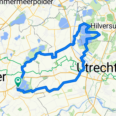
De Franse tijd route
A cycling route starting in Bloemendaal, South Holland, The Netherlands.
Overview
About this route
A beautiful round trip from Gouda via Haastrecht, Vlist (Franse Kade and Bonrepas), Schoonhoven, Cabouw, Polsbroekerdam, Oudewater, Papekop, Waarder, Driebruggen, Sluipwijk, Reeuwijk-Brug, back to Gouda.
- 1 h 28 min
- Duration
- 48.7 km
- Distance
- 0 m
- Ascent
- 0 m
- Descent
- 33.4 km/h
- Avg. speed
- ---
- Max. altitude

Route quality
Waytypes & surfaces along the route
Waytypes
Cycleway
22.9 km
(47 %)
Quiet road
19 km
(39 %)
Surfaces
Paved
20.5 km
(42 %)
Unpaved
0.5 km
(1 %)
Asphalt
20.5 km
(42 %)
Loose gravel
0.5 km
(1 %)
Undefined
27.8 km
(57 %)
Continue with Bikemap
Use, edit, or download this cycling route
You would like to ride De Franse tijd route or customize it for your own trip? Here is what you can do with this Bikemap route:
Free features
- Save this route as favorite or in collections
- Copy & plan your own version of this route
- Sync your route with Garmin or Wahoo
Premium features
Free trial for 3 days, or one-time payment. More about Bikemap Premium.
- Navigate this route on iOS & Android
- Export a GPX / KML file of this route
- Create your custom printout (try it for free)
- Download this route for offline navigation
Discover more Premium features.
Get Bikemap PremiumFrom our community
Other popular routes starting in Bloemendaal
 Gouda - Woerden v.v.
- Distance
- 46.3 km
- Ascent
- 0 m
- Descent
- 0 m
- Location
- Bloemendaal, South Holland, The Netherlands
 rond om Reeuwijkse plassen
- Distance
- 19.2 km
- Ascent
- 12 m
- Descent
- 12 m
- Location
- Bloemendaal, South Holland, The Netherlands
 gouda
gouda- Distance
- 30.1 km
- Ascent
- 0 m
- Descent
- 0 m
- Location
- Bloemendaal, South Holland, The Netherlands
 Waddinxveen/Bentwoud
- Distance
- 27.1 km
- Ascent
- 40 m
- Descent
- 34 m
- Location
- Bloemendaal, South Holland, The Netherlands
 De Franse tijd route
- Distance
- 48.7 km
- Ascent
- 0 m
- Descent
- 0 m
- Location
- Bloemendaal, South Holland, The Netherlands
 Zondag's rondje bij mooi weer.
- Distance
- 36.7 km
- Ascent
- 4 m
- Descent
- 4 m
- Location
- Bloemendaal, South Holland, The Netherlands
 first 101
- Distance
- 107 km
- Ascent
- 5 m
- Descent
- 5 m
- Location
- Bloemendaal, South Holland, The Netherlands
 Weegje Reeuwijk gouda
- Distance
- 35.2 km
- Ascent
- 10 m
- Descent
- 9 m
- Location
- Bloemendaal, South Holland, The Netherlands
Open it in the app