

2009 Frosch Radweg--Schwepnitz bis Spremberg/Spree
A cycling route starting in Schwepnitz, Saxony, Germany.
Overview
About this route
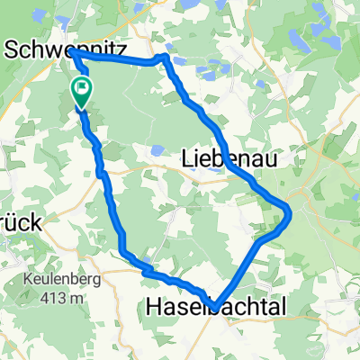
From Schwepnitz first to Grüngräbchen, there I followed the marked Frosch cycling path, through a lot of open pine forest, in beautiful sunshine over Hoyerswerda, behind the city through former mining areas and beautiful heathland to the Spree cycling path.
- -:--
- Duration
- 66 km
- Distance
- 144 m
- Ascent
- 182 m
- Descent
- ---
- Avg. speed
- 191 m
- Max. altitude
Route quality
Waytypes & surfaces along the route
Waytypes
Cycleway
15.8 km
(24 %)
Quiet road
15.2 km
(23 %)
Surfaces
Paved
32.3 km
(49 %)
Unpaved
11.2 km
(17 %)
Asphalt
30.4 km
(46 %)
Gravel
7.3 km
(11 %)
Route highlights
Points of interest along the route
Point of interest after 16.2 km
Supermarkt
Point of interest after 25.4 km
Gaststätte Kaffee Pause
Point of interest after 31.8 km
Mittagspause auf Bank
Point of interest after 66 km
Pension Am Burg Lehnchen DZ 50 Euro
Continue with Bikemap
Use, edit, or download this cycling route
You would like to ride 2009 Frosch Radweg--Schwepnitz bis Spremberg/Spree or customize it for your own trip? Here is what you can do with this Bikemap route:
Free features
- Save this route as favorite or in collections
- Copy & plan your own version of this route
- Sync your route with Garmin or Wahoo
Premium features
Free trial for 3 days, or one-time payment. More about Bikemap Premium.
- Navigate this route on iOS & Android
- Export a GPX / KML file of this route
- Create your custom printout (try it for free)
- Download this route for offline navigation
Discover more Premium features.
Get Bikemap PremiumFrom our community
Other popular routes starting in Schwepnitz
 Kleine Trainingsrunde
- Distance
- 33.1 km
- Ascent
- 239 m
- Descent
- 237 m
- Location
- Schwepnitz, Saxony, Germany
 Schulstraße 2, Schwepnitz nach Schulstraße 2, Schwepnitz
- Distance
- 32.7 km
- Ascent
- 534 m
- Descent
- 551 m
- Location
- Schwepnitz, Saxony, Germany
 Schwepnitz - Wittichenau - Boxberg (Tag 1 von 4)
- Distance
- 62.1 km
- Ascent
- 180 m
- Descent
- 193 m
- Location
- Schwepnitz, Saxony, Germany
 Schulstraße, Schwepnitz nach Oststraße 55, Schwepnitz
- Distance
- 30.4 km
- Ascent
- 485 m
- Descent
- 476 m
- Location
- Schwepnitz, Saxony, Germany
 Hoshis Longrun
- Distance
- 135.6 km
- Ascent
- 229 m
- Descent
- 229 m
- Location
- Schwepnitz, Saxony, Germany
 2009 Frosch Radweg--Schwepnitz bis Spremberg/Spree
- Distance
- 66 km
- Ascent
- 144 m
- Descent
- 182 m
- Location
- Schwepnitz, Saxony, Germany
 Teichetour um Heidebogen
- Distance
- 46 km
- Ascent
- 390 m
- Descent
- 388 m
- Location
- Schwepnitz, Saxony, Germany
 Keulenbergrunde
- Distance
- 32.9 km
- Ascent
- 309 m
- Descent
- 309 m
- Location
- Schwepnitz, Saxony, Germany
Open it in the app