

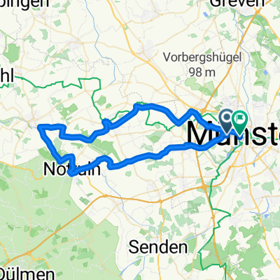
20150525_184035.gpx
A cycling route starting in Münster, North Rhine-Westphalia, Germany.
Overview
About this route
TEASI track
- -:--
- Duration
- 3.8 km
- Distance
- 16 m
- Ascent
- 24 m
- Descent
- ---
- Avg. speed
- ---
- Max. altitude
Route quality
Waytypes & surfaces along the route
Waytypes
Path
3.1 km
(80 %)
Road
0.3 km
(8 %)
Surfaces
Paved
2.4 km
(63 %)
Unpaved
1.3 km
(35 %)
Paving stones
1.5 km
(40 %)
Gravel
1.3 km
(35 %)
Route highlights
Points of interest along the route
Point of interest after 1.9 km
Heidegrund (Münster-Nord)
Continue with Bikemap
Use, edit, or download this cycling route
You would like to ride 20150525_184035.gpx or customize it for your own trip? Here is what you can do with this Bikemap route:
Free features
- Save this route as favorite or in collections
- Copy & plan your own version of this route
- Sync your route with Garmin or Wahoo
Premium features
Free trial for 3 days, or one-time payment. More about Bikemap Premium.
- Navigate this route on iOS & Android
- Export a GPX / KML file of this route
- Create your custom printout (try it for free)
- Download this route for offline navigation
Discover more Premium features.
Get Bikemap PremiumFrom our community
Other popular routes starting in Münster
 Hohe Ward Rundweg
- Distance
- 36.9 km
- Ascent
- 49 m
- Descent
- 48 m
- Location
- Münster, North Rhine-Westphalia, Germany
 Giro 2010 55km
- Distance
- 56 km
- Ascent
- 238 m
- Descent
- 242 m
- Location
- Münster, North Rhine-Westphalia, Germany
 MS-Rieselfelder-Telgte-MS
- Distance
- 52 km
- Ascent
- 99 m
- Descent
- 99 m
- Location
- Münster, North Rhine-Westphalia, Germany
 Campingplatz - Emsauen- u. Kanal-Tour
- Distance
- 53.2 km
- Ascent
- 182 m
- Descent
- 179 m
- Location
- Münster, North Rhine-Westphalia, Germany
 Samstagnachmittagsrunde: 117 km Teuto/Schafberg
- Distance
- 117.5 km
- Ascent
- 635 m
- Descent
- 651 m
- Location
- Münster, North Rhine-Westphalia, Germany
 Giro 2011 - 110 km Strecke
- Distance
- 111.7 km
- Ascent
- 238 m
- Descent
- 235 m
- Location
- Münster, North Rhine-Westphalia, Germany
 MS 01
MS 01- Distance
- 35.9 km
- Ascent
- 48 m
- Descent
- 46 m
- Location
- Münster, North Rhine-Westphalia, Germany
 Münster - Telgte - Münster
- Distance
- 39.6 km
- Ascent
- 43 m
- Descent
- 44 m
- Location
- Münster, North Rhine-Westphalia, Germany
Open it in the app