Türkenbach-Holzlandrunde
A cycling route starting in Stammham, Bavaria, Germany.
Overview
About this route
Through the 'Holzland', a part of the tertiary hill country up and down - with the occasional failed shortcut on forest and meadow paths. The Radler pint with the Grenzland cyclists was well deserved.
- -:--
- Duration
- 61.2 km
- Distance
- 511 m
- Ascent
- 511 m
- Descent
- ---
- Avg. speed
- ---
- Max. altitude
Route quality
Waytypes & surfaces along the route
Waytypes
Quiet road
31.2 km
(51 %)
Road
17.1 km
(28 %)
Surfaces
Paved
42.2 km
(69 %)
Unpaved
4.3 km
(7 %)
Asphalt
41.6 km
(68 %)
Gravel
3.7 km
(6 %)
Route highlights
Points of interest along the route
Point of interest after 48.7 km
Tafelberg: Trachtenfest der "Grenzlandler"
Continue with Bikemap
Use, edit, or download this cycling route
You would like to ride Türkenbach-Holzlandrunde or customize it for your own trip? Here is what you can do with this Bikemap route:
Free features
- Save this route as favorite or in collections
- Copy & plan your own version of this route
- Sync your route with Garmin or Wahoo
Premium features
Free trial for 3 days, or one-time payment. More about Bikemap Premium.
- Navigate this route on iOS & Android
- Export a GPX / KML file of this route
- Create your custom printout (try it for free)
- Download this route for offline navigation
Discover more Premium features.
Get Bikemap PremiumFrom our community
Other popular routes starting in Stammham
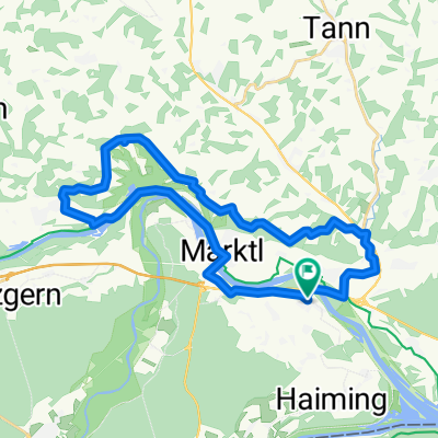
Niedergottsauer Innleiten-Runde (Untertürken-Perach)- Distance
- 29.8 km
- Ascent
- 265 m
- Descent
- 268 m
- Location
- Stammham, Bavaria, Germany
Innspitzrunde: Haiming - Simbach -Burghausen- Distance
- 53.1 km
- Ascent
- 179 m
- Descent
- 178 m
- Location
- Stammham, Bavaria, Germany
Einmal Bergham und zurück- Distance
- 15.3 km
- Ascent
- 51 m
- Descent
- 52 m
- Location
- Stammham, Bavaria, Germany
RC RITZLFUCHSER: Tourenradler Saisonfinale 01.10.16- Distance
- 43.3 km
- Ascent
- 217 m
- Descent
- 217 m
- Location
- Stammham, Bavaria, Germany
Türkenbach-Holzlandrunde- Distance
- 61.2 km
- Ascent
- 511 m
- Descent
- 511 m
- Location
- Stammham, Bavaria, Germany
Innleitn-Runde- Distance
- 43.4 km
- Ascent
- 441 m
- Descent
- 441 m
- Location
- Stammham, Bavaria, Germany
erweiterte Innspitzrunde- Distance
- 82.5 km
- Ascent
- 418 m
- Descent
- 417 m
- Location
- Stammham, Bavaria, Germany
Bruckmühl Burghausen Altötting und zurück- Distance
- 46.2 km
- Ascent
- 172 m
- Descent
- 173 m
- Location
- Stammham, Bavaria, Germany
Open it in the app


