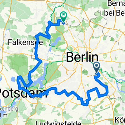
Südostrunde 90 km
A cycling route starting in Plänterwald, State of Berlin, Germany.
Overview
About this route
The route starts along the bike path parallel to the canal. However, it is heavily frequented in good weather, so caution is advised—especially with larger groups.
After bypassing the BBI construction site, the route leads to Brusendorf, where you can turn back towards Glasow/Dahlewitz if needed.
In Mittenwalde, there is an option to extend the ride via Motzen, Kallinchen, and Schöneiche (about 11 km extra).
On the way back, there is a fairly good bike path alongside the B96, although it features some bollards.
- -:--
- Duration
- 89.8 km
- Distance
- 196 m
- Ascent
- 187 m
- Descent
- ---
- Avg. speed
- 62 m
- Max. altitude
Route quality
Waytypes & surfaces along the route
Waytypes
Path
25.1 km
(28 %)
Quiet road
20.6 km
(23 %)
Surfaces
Paved
81.7 km
(91 %)
Unpaved
1.8 km
(2 %)
Asphalt
79.9 km
(89 %)
Concrete
1.8 km
(2 %)
Continue with Bikemap
Use, edit, or download this cycling route
You would like to ride Südostrunde 90 km or customize it for your own trip? Here is what you can do with this Bikemap route:
Free features
- Save this route as favorite or in collections
- Copy & plan your own version of this route
- Split it into stages to create a multi-day tour
- Sync your route with Garmin or Wahoo
Premium features
Free trial for 3 days, or one-time payment. More about Bikemap Premium.
- Navigate this route on iOS & Android
- Export a GPX / KML file of this route
- Create your custom printout (try it for free)
- Download this route for offline navigation
Discover more Premium features.
Get Bikemap PremiumFrom our community
Other popular routes starting in Plänterwald
- Müggelseerunde
- Distance
- 48 km
- Ascent
- 71 m
- Descent
- 69 m
- Location
- Plänterwald, State of Berlin, Germany
- Lasso-Runde
- Distance
- 91.9 km
- Ascent
- 118 m
- Descent
- 118 m
- Location
- Plänterwald, State of Berlin, Germany
- Rund um West-Berlin (Mauerweg RR)
- Distance
- 139.9 km
- Ascent
- 190 m
- Descent
- 185 m
- Location
- Plänterwald, State of Berlin, Germany
- Südostrunde 90 km
- Distance
- 89.8 km
- Ascent
- 196 m
- Descent
- 187 m
- Location
- Plänterwald, State of Berlin, Germany
- Feierabendrunde_Neukölln_Schönefeld
- Distance
- 38.7 km
- Ascent
- 47 m
- Descent
- 46 m
- Location
- Plänterwald, State of Berlin, Germany
- Rund um West-Berlin (Mauerweg RR)
- Distance
- 139.7 km
- Ascent
- 335 m
- Descent
- 332 m
- Location
- Plänterwald, State of Berlin, Germany
- Rixdorf, Müggelsee, durch den Forst zurück
- Distance
- 45.7 km
- Ascent
- 62 m
- Descent
- 62 m
- Location
- Plänterwald, State of Berlin, Germany
- Rixdorf, Müggelsee, durch den Forst zurück CLONED FROM ROUTE 241450
- Distance
- 45.8 km
- Ascent
- 67 m
- Descent
- 77 m
- Location
- Plänterwald, State of Berlin, Germany
Open it in the app