

E5-1 Vauxrenard bis St-Agathe en Donzy 100 km 2200 HM
A cycling route starting in Fleurie, Auvergne-Rhône-Alpes, France.
Overview
About this route
sehr viele hügel
- -:--
- Duration
- 99.4 km
- Distance
- 1,522 m
- Ascent
- 1,281 m
- Descent
- ---
- Avg. speed
- ---
- Max. altitude
Route quality
Waytypes & surfaces along the route
Waytypes
Road
56.6 km
(57 %)
Quiet road
15.9 km
(16 %)
Surfaces
Paved
17.9 km
(18 %)
Unpaved
2 km
(2 %)
Asphalt
16.9 km
(17 %)
Paved (undefined)
1 km
(1 %)
Continue with Bikemap
Use, edit, or download this cycling route
You would like to ride E5-1 Vauxrenard bis St-Agathe en Donzy 100 km 2200 HM or customize it for your own trip? Here is what you can do with this Bikemap route:
Free features
- Save this route as favorite or in collections
- Copy & plan your own version of this route
- Split it into stages to create a multi-day tour
- Sync your route with Garmin or Wahoo
Premium features
Free trial for 3 days, or one-time payment. More about Bikemap Premium.
- Navigate this route on iOS & Android
- Export a GPX / KML file of this route
- Create your custom printout (try it for free)
- Download this route for offline navigation
Discover more Premium features.
Get Bikemap PremiumFrom our community
Other popular routes starting in Fleurie
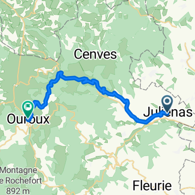
 Route to Juliénas
- Distance
- 36 km
- Ascent
- 875 m
- Descent
- 875 m
- Location
- Fleurie, Auvergne-Rhône-Alpes, France
 Juliénas to Ouroux Direct via Siberie
- Distance
- 16.1 km
- Ascent
- 494 m
- Descent
- 316 m
- Location
- Fleurie, Auvergne-Rhône-Alpes, France
 De Juliénas à Juliénas
- Distance
- 33.7 km
- Ascent
- 872 m
- Descent
- 872 m
- Location
- Fleurie, Auvergne-Rhône-Alpes, France
 48 km Bourgongne - Beaujolais
- Distance
- 47.7 km
- Ascent
- 693 m
- Descent
- 696 m
- Location
- Fleurie, Auvergne-Rhône-Alpes, France
 50 km Monts de Beaujolais
- Distance
- 50 km
- Ascent
- 732 m
- Descent
- 733 m
- Location
- Fleurie, Auvergne-Rhône-Alpes, France
 Julienas
- Distance
- 56.9 km
- Ascent
- 770 m
- Descent
- 765 m
- Location
- Fleurie, Auvergne-Rhône-Alpes, France
 Rondje Fleurie
- Distance
- 43 km
- Ascent
- 411 m
- Descent
- 411 m
- Location
- Fleurie, Auvergne-Rhône-Alpes, France
 41 km Juliénas - Route de cols et AOCs
- Distance
- 40.4 km
- Ascent
- 668 m
- Descent
- 668 m
- Location
- Fleurie, Auvergne-Rhône-Alpes, France
Open it in the app