

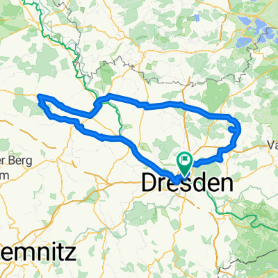
20. SZ-Fahrradfest – 65 km Sparkassen-Tour (RTF 3)
A cycling route starting in Dresden, Saxony, Germany.
Overview
About this route
- SZ-Fahrradfest – 65 km Sparkassen-Tour (RTF 3)
(cloned from route 3027731)
- -:--
- Duration
- 62.3 km
- Distance
- 371 m
- Ascent
- 372 m
- Descent
- ---
- Avg. speed
- ---
- Max. altitude
Route quality
Waytypes & surfaces along the route
Waytypes
Busy road
30 km
(48 %)
Quiet road
9.7 km
(16 %)
Surfaces
Paved
56.5 km
(91 %)
Unpaved
1 km
(2 %)
Asphalt
52.1 km
(84 %)
Paving stones
4.3 km
(7 %)
Route highlights
Points of interest along the route
Point of interest after 1.2 km
Tourteilung: ( 11,30 Km von 45, 65 Km )
Point of interest after 4.7 km
Aufhebung des geschlossenen Verbands
\"")
Point of interest after 22.2 km
Verpflegungspunkt - Kreischa DEKRA Gelände
Point of interest after 23.2 km
Tourteilung (45 km von 65 Km )
\"")
Drinking water after 45.5 km
Getränkepunkt - Heidenau Radrennbahn
Continue with Bikemap
Use, edit, or download this cycling route
You would like to ride 20. SZ-Fahrradfest – 65 km Sparkassen-Tour (RTF 3) or customize it for your own trip? Here is what you can do with this Bikemap route:
Free features
- Save this route as favorite or in collections
- Copy & plan your own version of this route
- Sync your route with Garmin or Wahoo
Premium features
Free trial for 3 days, or one-time payment. More about Bikemap Premium.
- Navigate this route on iOS & Android
- Export a GPX / KML file of this route
- Create your custom printout (try it for free)
- Download this route for offline navigation
Discover more Premium features.
Get Bikemap PremiumFrom our community
Other popular routes starting in Dresden
 Dresden - Altenberg
- Distance
- 52.7 km
- Ascent
- 1,016 m
- Descent
- 385 m
- Location
- Dresden, Saxony, Germany
 Schmorsdorfer Höhenrunde
- Distance
- 49.8 km
- Ascent
- 510 m
- Descent
- 488 m
- Location
- Dresden, Saxony, Germany
 Dresden - Stolpen -Rathen
- Distance
- 54 km
- Ascent
- 447 m
- Descent
- 446 m
- Location
- Dresden, Saxony, Germany
 Ponickau
- Distance
- 122.5 km
- Ascent
- 320 m
- Descent
- 323 m
- Location
- Dresden, Saxony, Germany
 cielab.org - Dresden - Bahratal - Mückentürmchen
- Distance
- 130 km
- Ascent
- 1,524 m
- Descent
- 1,516 m
- Location
- Dresden, Saxony, Germany
 DD-Collm-Riesa-Keulenberg-DD
- Distance
- 196.8 km
- Ascent
- 1,000 m
- Descent
- 904 m
- Location
- Dresden, Saxony, Germany
 Strecke - Erdgas Race Day-Speed-Challenge 2009
- Distance
- 63.4 km
- Ascent
- 515 m
- Descent
- 496 m
- Location
- Dresden, Saxony, Germany
 Rennradrunde um den Tharandter Wald
- Distance
- 78.9 km
- Ascent
- 934 m
- Descent
- 850 m
- Location
- Dresden, Saxony, Germany
Open it in the app