20-Mile Run Around Sierra Vista up to the end of Yaqui St.
A cycling route starting in Sierra Vista, Arizona, United States of America.
Overview
About this route
This is a nice ride that takes you to the end of the pavement off Yaqui Street, which gives you a nice view of the Huachuca mountains.
- -:--
- Duration
- 32.1 km
- Distance
- 134 m
- Ascent
- 145 m
- Descent
- ---
- Avg. speed
- 1,500 m
- Avg. speed
Route quality
Waytypes & surfaces along the route
Waytypes
Cycleway
10.1 km
(31 %)
Busy road
9.3 km
(29 %)
Surfaces
Paved
6.1 km
(19 %)
Unpaved
0 km
(<1 %)
Asphalt
6 km
(19 %)
Paved (undefined)
0.2 km
(<1 %)
Continue with Bikemap
Use, edit, or download this cycling route
You would like to ride 20-Mile Run Around Sierra Vista up to the end of Yaqui St. or customize it for your own trip? Here is what you can do with this Bikemap route:
Free features
- Save this route as favorite or in collections
- Copy & plan your own version of this route
- Sync your route with Garmin or Wahoo
Premium features
Free trial for 3 days, or one-time payment. More about Bikemap Premium.
- Navigate this route on iOS & Android
- Export a GPX / KML file of this route
- Create your custom printout (try it for free)
- Download this route for offline navigation
Discover more Premium features.
Get Bikemap PremiumFrom our community
Other popular routes starting in Sierra Vista
- St. Andrews path
- Distance
- 12.6 km
- Ascent
- 92 m
- Descent
- 69 m
- Location
- Sierra Vista, Arizona, United States of America
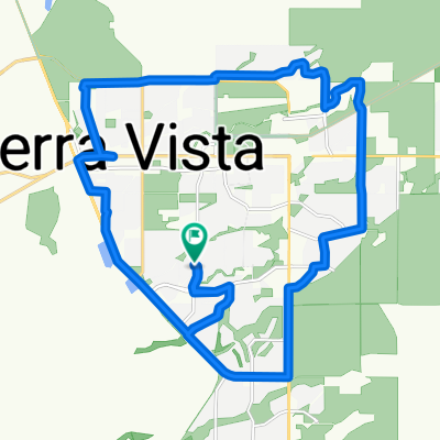
- Copper Sky Drive 2533, Sierra Vista to Lexington Drive 1901, Sierra Vista
- Distance
- 33.9 km
- Ascent
- 915 m
- Descent
- 872 m
- Location
- Sierra Vista, Arizona, United States of America
- Bisbee via Palominas
- Distance
- 110.5 km
- Ascent
- 897 m
- Descent
- 897 m
- Location
- Sierra Vista, Arizona, United States of America
- Lexington Drive 1901, Sierra Vista to Lexington Drive 1901, Sierra Vista
- Distance
- 23.5 km
- Ascent
- 1,034 m
- Descent
- 1,035 m
- Location
- Sierra Vista, Arizona, United States of America
- 32-Mile trip to the old Border Patrol check-point and back
- Distance
- 53.2 km
- Ascent
- 168 m
- Descent
- 153 m
- Location
- Sierra Vista, Arizona, United States of America
- SV to Palominas via Hereford Rd/San Pedro
- Distance
- 78.1 km
- Ascent
- 400 m
- Descent
- 413 m
- Location
- Sierra Vista, Arizona, United States of America
- SV to Tombstone Loop
- Distance
- 76.1 km
- Ascent
- 524 m
- Descent
- 524 m
- Location
- Sierra Vista, Arizona, United States of America
- El Mercado Loop 2200, Sierra Vista to El Mercado Loop 2200, Sierra Vista
- Distance
- 15 km
- Ascent
- 73 m
- Descent
- 74 m
- Location
- Sierra Vista, Arizona, United States of America
Open it in the app