

Drei Schusterhütte
A cycling route starting in Sexten, Trentino-Alto Adige, Italy.
Overview
About this route
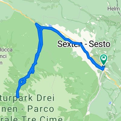
This easy half-day tour starts in Sexten/Moos along the bike path towards Innichen up to the parking lot at the entrance to the Innerfeld Valley. From there, you follow the traffic-free asphalt road to the Drei Schusterhütte. On the way back, you take a very nice, flowing trail back to the Gasthof Klaus, and from there along the bike path back to Sexten/Moos.
- -:--
- Duration
- 22.4 km
- Distance
- 502 m
- Ascent
- 502 m
- Descent
- ---
- Avg. speed
- ---
- Max. altitude
Continue with Bikemap
Use, edit, or download this cycling route
You would like to ride Drei Schusterhütte or customize it for your own trip? Here is what you can do with this Bikemap route:
Free features
- Save this route as favorite or in collections
- Copy & plan your own version of this route
- Sync your route with Garmin or Wahoo
Premium features
Free trial for 3 days, or one-time payment. More about Bikemap Premium.
- Navigate this route on iOS & Android
- Export a GPX / KML file of this route
- Create your custom printout (try it for free)
- Download this route for offline navigation
Discover more Premium features.
Get Bikemap PremiumFrom our community
Other popular routes starting in Sexten
 Drei Schusterhütte
- Distance
- 22.4 km
- Ascent
- 502 m
- Descent
- 502 m
- Location
- Sexten, Trentino-Alto Adige, Italy
 Rundtour 3 Zinnen
- Distance
- 90.7 km
- Ascent
- 1,905 m
- Descent
- 1,717 m
- Location
- Sexten, Trentino-Alto Adige, Italy
 14: Dolomites a peu, volta al Tre Cime di Lavaredo
- Distance
- 10 km
- Ascent
- 406 m
- Descent
- 409 m
- Location
- Sexten, Trentino-Alto Adige, Italy
 1. DER MONTE SPINA TRAIL DAS ABSOLUTE MTB HIHLIGHT
- Distance
- 42.5 km
- Ascent
- 1,910 m
- Descent
- 1,913 m
- Location
- Sexten, Trentino-Alto Adige, Italy
 Rifugio 3 scarperi - Monte Caselle di Fuori
- Distance
- 15.6 km
- Ascent
- 0 m
- Descent
- 0 m
- Location
- Sexten, Trentino-Alto Adige, Italy
 Cotrondo Alm
- Distance
- 19.1 km
- Ascent
- 711 m
- Descent
- 711 m
- Location
- Sexten, Trentino-Alto Adige, Italy
 1. DER MONTE SPINA TRAIL DAS ABSOLUTE MTB HIHLIGHT
- Distance
- 42.4 km
- Ascent
- 1,906 m
- Descent
- 1,909 m
- Location
- Sexten, Trentino-Alto Adige, Italy
 Helm rauf und runter
- Distance
- 18.9 km
- Ascent
- 849 m
- Descent
- 849 m
- Location
- Sexten, Trentino-Alto Adige, Italy
Open it in the app