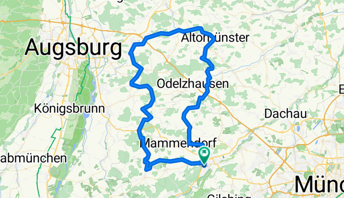
Von FFB ins Dachauer Hinterland
A cycling route starting in Fürstenfeldbruck, Bavaria, Germany.
Overview
About this route
always low traffic, even on excursion days, where the fun comes to an end at Lake Ammersee and Lake Starnberger
- -:--
- Duration
- 100.9 km
- Distance
- 704 m
- Ascent
- 689 m
- Descent
- ---
- Avg. speed
- 560 m
- Max. altitude
Route quality
Waytypes & surfaces along the route
Waytypes
Quiet road
51.5 km
(51 %)
Road
34.3 km
(34 %)
Surfaces
Paved
76.7 km
(76 %)
Unpaved
4 km
(4 %)
Asphalt
76.7 km
(76 %)
Ground
2 km
(2 %)
Continue with Bikemap
Use, edit, or download this cycling route
You would like to ride Von FFB ins Dachauer Hinterland or customize it for your own trip? Here is what you can do with this Bikemap route:
Free features
- Save this route as favorite or in collections
- Copy & plan your own version of this route
- Split it into stages to create a multi-day tour
- Sync your route with Garmin or Wahoo
Premium features
Free trial for 3 days, or one-time payment. More about Bikemap Premium.
- Navigate this route on iOS & Android
- Export a GPX / KML file of this route
- Create your custom printout (try it for free)
- Download this route for offline navigation
Discover more Premium features.
Get Bikemap PremiumFrom our community
Other popular routes starting in Fürstenfeldbruck
- Sonntagsrunde Schöngeisinger Wald
- Distance
- 33 km
- Ascent
- 267 m
- Descent
- 223 m
- Location
- Fürstenfeldbruck, Bavaria, Germany
- Von FFB ins Dachauer Hinterland
- Distance
- 100.9 km
- Ascent
- 704 m
- Descent
- 689 m
- Location
- Fürstenfeldbruck, Bavaria, Germany
- Escursione in bici con Laura e Marco
- Distance
- 43.4 km
- Ascent
- 231 m
- Descent
- 229 m
- Location
- Fürstenfeldbruck, Bavaria, Germany
- Fürstenfeldbruck-Kaltenberg
- Distance
- 64 km
- Ascent
- 550 m
- Descent
- 553 m
- Location
- Fürstenfeldbruck, Bavaria, Germany
- Abendrunde
- Distance
- 20.5 km
- Ascent
- 130 m
- Descent
- 130 m
- Location
- Fürstenfeldbruck, Bavaria, Germany
- Wörthsee, Pilsensee, Ammersee
- Distance
- 57.3 km
- Ascent
- 1,095 m
- Descent
- 1,106 m
- Location
- Fürstenfeldbruck, Bavaria, Germany
- FFB Rotschweiger Wald Grafrath
- Distance
- 19.9 km
- Ascent
- 79 m
- Descent
- 72 m
- Location
- Fürstenfeldbruck, Bavaria, Germany
- FFB - Andechs - Bernried - Gilching - FFB
- Distance
- 101.1 km
- Ascent
- 976 m
- Descent
- 930 m
- Location
- Fürstenfeldbruck, Bavaria, Germany
Open it in the app