

Col de Chérel and Col du Plane
A cycling route starting in Annecy, Auvergne-Rhône-Alpes, France.
Overview
About this route
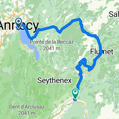
Challenging loop in the Bauges Alps. Note top half of bothe climbs are unpaved and often very rough.
- -:--
- Duration
- 85 km
- Distance
- 1,744 m
- Ascent
- 1,745 m
- Descent
- ---
- Avg. speed
- ---
- Max. altitude

Route highlights
Points of interest along the route
Point of interest after 32.2 km
Col de Chérel
Point of interest after 54 km
Col du Plane
Point of interest after 69.9 km
Col des Leschaux
Continue with Bikemap
Use, edit, or download this cycling route
You would like to ride Col de Chérel and Col du Plane or customize it for your own trip? Here is what you can do with this Bikemap route:
Free features
- Save this route as favorite or in collections
- Copy & plan your own version of this route
- Split it into stages to create a multi-day tour
- Sync your route with Garmin or Wahoo
Premium features
Free trial for 3 days, or one-time payment. More about Bikemap Premium.
- Navigate this route on iOS & Android
- Export a GPX / KML file of this route
- Create your custom printout (try it for free)
- Download this route for offline navigation
Discover more Premium features.
Get Bikemap PremiumFrom our community
Other popular routes starting in Annecy
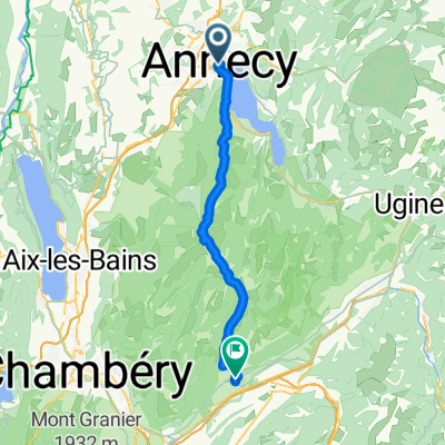
 Day 1 - Annecy to Montgilbert
- Distance
- 60.9 km
- Ascent
- 767 m
- Descent
- 678 m
- Location
- Annecy, Auvergne-Rhône-Alpes, France
 FORCLAZ MONTMIN VERSANT SUD 31MAI 2014
- Distance
- 54.5 km
- Ascent
- 757 m
- Descent
- 759 m
- Location
- Annecy, Auvergne-Rhône-Alpes, France
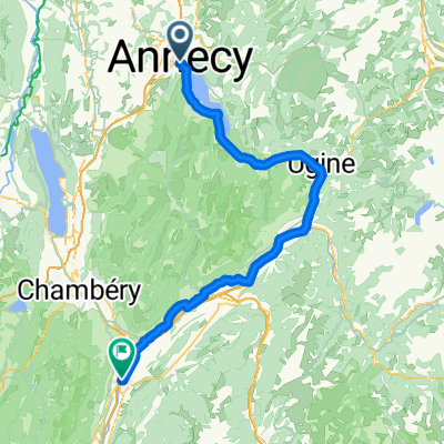
 Route in Annecy
- Distance
- 39.3 km
- Ascent
- 345 m
- Descent
- 347 m
- Location
- Annecy, Auvergne-Rhône-Alpes, France
 Rhone-Alpes: Etappe 1
- Distance
- 100.2 km
- Ascent
- 1,888 m
- Descent
- 1,997 m
- Location
- Annecy, Auvergne-Rhône-Alpes, France
 Almenroute
- Distance
- 52.9 km
- Ascent
- 901 m
- Descent
- 992 m
- Location
- Annecy, Auvergne-Rhône-Alpes, France
 02 Annecy-Moûtiers
- Distance
- 70.8 km
- Ascent
- 294 m
- Descent
- 268 m
- Location
- Annecy, Auvergne-Rhône-Alpes, France
 Annecy - Pontcharra
- Distance
- 92.5 km
- Ascent
- 278 m
- Descent
- 475 m
- Location
- Annecy, Auvergne-Rhône-Alpes, France
 Annecy to Bormio
- Distance
- 732.2 km
- Ascent
- 9,503 m
- Descent
- 8,752 m
- Location
- Annecy, Auvergne-Rhône-Alpes, France
Open it in the app