

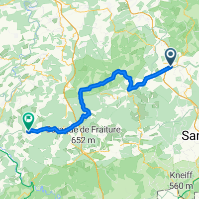
Rondje ardennen 74 km
A cycling route starting in Malmedy, Wallonia, Belgium.
Overview
About this route
Ardennes loop 72.5 km with various nice little climbs
- -:--
- Duration
- 74 km
- Distance
- 1,228 m
- Ascent
- 1,228 m
- Descent
- ---
- Avg. speed
- ---
- Max. altitude

Route quality
Waytypes & surfaces along the route
Waytypes
Road
39.2 km
(53 %)
Quiet road
12.6 km
(17 %)
Surfaces
Paved
31.8 km
(43 %)
Unpaved
3.7 km
(5 %)
Asphalt
31.8 km
(43 %)
Ground
3.7 km
(5 %)
Undefined
38.5 km
(52 %)
Route highlights
Points of interest along the route
Point of interest after 2 km
Ferme Libert Hoogteverschil : 154m Lengte : 1.25 km Gem. steiging : 12.3%
Point of interest after 2.8 km
Top Ferme Libert
Point of interest after 4.9 km
Klim onbekende naam
Point of interest after 6 km
Top klim onbekende naam
Point of interest after 7.8 km
Voet Route de lAncienne Douane
Point of interest after 9.9 km
Top Route de lAncienne Douane
Point of interest after 30 km
Thier de Coo Hoogteverschil : 221m Lengte : 2.6 km Gem. stijging : 8.5%
Point of interest after 33.2 km
Top Thier de Coo
Point of interest after 35.3 km
Stockeu Hoogteverschil : 227m Lengte : 2.3 km Gem. stijging : 9.9%
Point of interest after 37 km
Top Stockeu
Point of interest after 40.7 km
Wanneranval Stijgingspercentage 8.4% Maximaal (100m) 16.4% Lengte 1.7 km Hoogteverschil 142 m
Point of interest after 41.7 km
Top Wanneranval
Point of interest after 45.8 km
Mont le Soie (560m) Hoogteverschil : 235m Lengte : 4 km Gem. stijging : 5.9%
Point of interest after 50.2 km
Top Mont le Soie
Point of interest after 65.3 km
Thier de la Principauté (426m) Hoogteverschil : 100m Lengte : 1 km Gem. stijging : 10%
Point of interest after 66.3 km
Top Thier de la Principauté
Point of interest after 68.8 km
Côte de Cligneval (424m) Hoogteverschil : 109m Lengte : 1.6 km Gem. stijging : 6.8%
Point of interest after 69.9 km
Top Côte de Cligneval
Continue with Bikemap
Use, edit, or download this cycling route
You would like to ride Rondje ardennen 74 km or customize it for your own trip? Here is what you can do with this Bikemap route:
Free features
- Save this route as favorite or in collections
- Copy & plan your own version of this route
- Sync your route with Garmin or Wahoo
Premium features
Free trial for 3 days, or one-time payment. More about Bikemap Premium.
- Navigate this route on iOS & Android
- Export a GPX / KML file of this route
- Create your custom printout (try it for free)
- Download this route for offline navigation
Discover more Premium features.
Get Bikemap PremiumFrom our community
Other popular routes starting in Malmedy
 Trôs-Marets-Tal 9Km/160hm
- Distance
- 9.1 km
- Ascent
- 223 m
- Descent
- 222 m
- Location
- Malmedy, Wallonia, Belgium
 Malmedy - Érezée
- Distance
- 52.1 km
- Ascent
- 745 m
- Descent
- 758 m
- Location
- Malmedy, Wallonia, Belgium
 Hockai Malmédy Trois-Ponts Coo Francorchamps
- Distance
- 44.7 km
- Ascent
- 484 m
- Descent
- 484 m
- Location
- Malmedy, Wallonia, Belgium
 START
START- Distance
- 0.1 km
- Ascent
- 0 m
- Descent
- 0 m
- Location
- Malmedy, Wallonia, Belgium
 Rurtour 1
- Distance
- 58.7 km
- Ascent
- 359 m
- Descent
- 802 m
- Location
- Malmedy, Wallonia, Belgium
 Rondje Francochamps 49K
- Distance
- 49.1 km
- Ascent
- 812 m
- Descent
- 813 m
- Location
- Malmedy, Wallonia, Belgium
 Mdy - Stavelot
- Distance
- 37.6 km
- Ascent
- 1,112 m
- Descent
- 1,116 m
- Location
- Malmedy, Wallonia, Belgium
 B-Ardennen II-145 2000
- Distance
- 151.9 km
- Ascent
- 1,685 m
- Descent
- 1,684 m
- Location
- Malmedy, Wallonia, Belgium
Open it in the app