

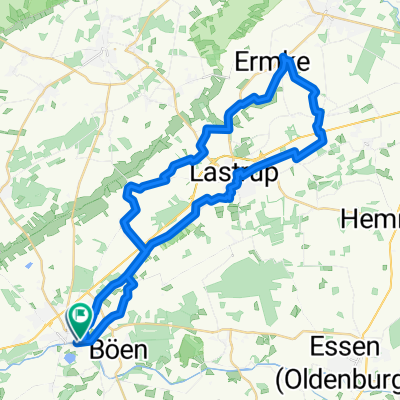
Hase-Ems-Tour (Tag3)
A cycling route starting in Löningen, Lower Saxony, Germany.
Overview
About this route
Hase-Ems Tour (Day 3)
- -:--
- Duration
- 58 km
- Distance
- 46 m
- Ascent
- 49 m
- Descent
- ---
- Avg. speed
- ---
- Max. altitude

Route photos
\"")
Route quality
Waytypes & surfaces along the route
Waytypes
Quiet road
20.3 km
(35 %)
Path
12.8 km
(22 %)
Surfaces
Paved
37.1 km
(64 %)
Unpaved
9.9 km
(17 %)
Asphalt
36 km
(62 %)
Gravel
7 km
(12 %)
Continue with Bikemap
Use, edit, or download this cycling route
You would like to ride Hase-Ems-Tour (Tag3) or customize it for your own trip? Here is what you can do with this Bikemap route:
Free features
- Save this route as favorite or in collections
- Copy & plan your own version of this route
- Sync your route with Garmin or Wahoo
Premium features
Free trial for 3 days, or one-time payment. More about Bikemap Premium.
- Navigate this route on iOS & Android
- Export a GPX / KML file of this route
- Create your custom printout (try it for free)
- Download this route for offline navigation
Discover more Premium features.
Get Bikemap PremiumFrom our community
Other popular routes starting in Löningen
 Berge 001
- Distance
- 35.4 km
- Ascent
- 71 m
- Descent
- 71 m
- Location
- Löningen, Lower Saxony, Germany
 Parkplatz Hasestraße - Torfcafe
- Distance
- 33.6 km
- Ascent
- 29 m
- Descent
- 30 m
- Location
- Löningen, Lower Saxony, Germany
 Löningen - Cloppenburg - Essen - Löningen
- Distance
- 61.7 km
- Ascent
- 65 m
- Descent
- 64 m
- Location
- Löningen, Lower Saxony, Germany
 Hase-Ems-Tour (Tag3)
- Distance
- 58 km
- Ascent
- 46 m
- Descent
- 49 m
- Location
- Löningen, Lower Saxony, Germany
 Löningen - Cloppenburg - Lindern - Löningen
- Distance
- 60.4 km
- Ascent
- 81 m
- Descent
- 81 m
- Location
- Löningen, Lower Saxony, Germany
 Hasestraße 18, Löningen nach Hasestraße 18, Löningen
- Distance
- 18.3 km
- Ascent
- 75 m
- Descent
- 75 m
- Location
- Löningen, Lower Saxony, Germany
 Von Löningen bis Leeuwarden
- Distance
- 278.2 km
- Ascent
- 439 m
- Descent
- 441 m
- Location
- Löningen, Lower Saxony, Germany
 LG010509
- Distance
- 40.9 km
- Ascent
- 45 m
- Descent
- 38 m
- Location
- Löningen, Lower Saxony, Germany
Open it in the app