

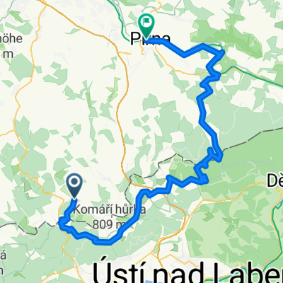
VKHč.1 Furstenau- NSG Fu.Heide- Traugothohe- Kohlhaukuppe-Zinwald-Cínovec-Cínovecký hřbet-
A cycling route starting in Geising, Saxony, Germany.
Overview
About this route
- -:--
- Duration
- 14.8 km
- Distance
- 301 m
- Ascent
- 313 m
- Descent
- ---
- Avg. speed
- ---
- Max. altitude

Route quality
Waytypes & surfaces along the route
Waytypes
Track
12.1 km
(81 %)
Quiet road
0.9 km
(6 %)
Surfaces
Paved
3.5 km
(23 %)
Unpaved
10.5 km
(71 %)
Ground
7 km
(47 %)
Asphalt
2.8 km
(19 %)
Route highlights
Points of interest along the route

Point of interest after 0.3 km
Stará poštovka Furstenau- Geising

Point of interest after 0.3 km
U Traugotthohe

Point of interest after 0.9 km

Point of interest after 0.9 km
NSG- Furstenauer Heide

Point of interest after 0.9 km
Pohled na Furstenau

Point of interest after 1.2 km

Point of interest after 1.6 km

Point of interest after 1.7 km

Point of interest after 2.9 km

Point of interest after 3.6 km
I. svačinová

Point of interest after 4.6 km

Point of interest after 5.9 km
Okolo cínoveckých mokřad

Point of interest after 7.3 km
Zienwald

Point of interest after 9.3 km
Kostel Nanebevzetí p. Marie

Point of interest after 9.4 km
Ve vřesovišti u Dlouhého rybníku

Point of interest after 9.8 km
Směr cínovecký hřbet

Point of interest after 10.1 km

Point of interest after 10.9 km
Krušnohorská magistrála, zadní Cínovec

Point of interest after 13.1 km

Point of interest after 13.6 km
Přední Cínovec
Continue with Bikemap
Use, edit, or download this cycling route
You would like to ride VKHč.1 Furstenau- NSG Fu.Heide- Traugothohe- Kohlhaukuppe-Zinwald-Cínovec-Cínovecký hřbet- or customize it for your own trip? Here is what you can do with this Bikemap route:
Free features
- Save this route as favorite or in collections
- Copy & plan your own version of this route
- Sync your route with Garmin or Wahoo
Premium features
Free trial for 3 days, or one-time payment. More about Bikemap Premium.
- Navigate this route on iOS & Android
- Export a GPX / KML file of this route
- Create your custom printout (try it for free)
- Download this route for offline navigation
Discover more Premium features.
Get Bikemap PremiumFrom our community
Other popular routes starting in Geising
 ErzgebirgsMAN 2009 NEW!!!
- Distance
- 257.4 km
- Ascent
- 4,193 m
- Descent
- 3,835 m
- Location
- Geising, Saxony, Germany
 VKHč.1 Furstenau- NSG Fu.Heide- Traugothohe- Kohlhaukuppe-Zinwald-Cínovec-Cínovecký hřbet-
- Distance
- 14.8 km
- Ascent
- 301 m
- Descent
- 313 m
- Location
- Geising, Saxony, Germany
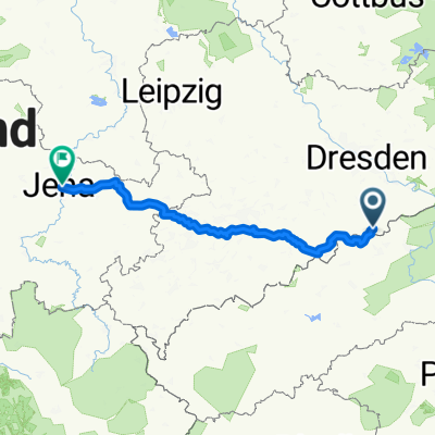 Geising - Jena, 2 Tage
- Distance
- 222.1 km
- Ascent
- 957 m
- Descent
- 1,534 m
- Location
- Geising, Saxony, Germany
 Kammtour - Geising nach Schöneck
- Distance
- 201.6 km
- Ascent
- 2,111 m
- Descent
- 1,936 m
- Location
- Geising, Saxony, Germany
 Hohe Tour
- Distance
- 43.2 km
- Ascent
- 345 m
- Descent
- 700 m
- Location
- Geising, Saxony, Germany
 Cínovec-Lesná
- Distance
- 58.1 km
- Ascent
- 677 m
- Descent
- 922 m
- Location
- Geising, Saxony, Germany
 tour 200718 vom kamm zur felsenlandschaft
- Distance
- 82.5 km
- Ascent
- 1,053 m
- Descent
- 1,525 m
- Location
- Geising, Saxony, Germany
 Služebka, Cínovec - DL - Klíny
- Distance
- 33.3 km
- Ascent
- 274 m
- Descent
- 415 m
- Location
- Geising, Saxony, Germany
Open it in the app