

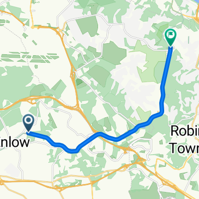
Macon to Chalon
A cycling route starting in Enlow, Pennsylvania, United States.
Overview
About this route
nice ride along the river
still some options to improve the bike track north of Tournus- -:--
- Duration
- 92.6 km
- Distance
- 381 m
- Ascent
- 373 m
- Descent
- ---
- Avg. speed
- ---
- Max. altitude
Continue with Bikemap
Use, edit, or download this cycling route
You would like to ride Macon to Chalon or customize it for your own trip? Here is what you can do with this Bikemap route:
Free features
- Save this route as favorite or in collections
- Copy & plan your own version of this route
- Split it into stages to create a multi-day tour
- Sync your route with Garmin or Wahoo
Premium features
Free trial for 3 days, or one-time payment. More about Bikemap Premium.
- Navigate this route on iOS & Android
- Export a GPX / KML file of this route
- Create your custom printout (try it for free)
- Download this route for offline navigation
Discover more Premium features.
Get Bikemap PremiumFrom our community
Other popular routes starting in Enlow
 Long ride from August 24, 5:52 PM
- Distance
- 32.1 km
- Ascent
- 265 m
- Descent
- 265 m
- Location
- Enlow, Pennsylvania, United States
 bike tour from September 15, 5:48 PM
- Distance
- 20.8 km
- Ascent
- 174 m
- Descent
- 169 m
- Location
- Enlow, Pennsylvania, United States
 Montour Trail 113, Coraopolis to Hassam Road, Moon Township
- Distance
- 9.7 km
- Ascent
- 7 m
- Descent
- 71 m
- Location
- Enlow, Pennsylvania, United States
 McClaren Road 39, Coraopolis to McClaren Road 39, Coraopolis
- Distance
- 7.1 km
- Ascent
- 90 m
- Descent
- 89 m
- Location
- Enlow, Pennsylvania, United States
 McClaren Road 24, Coraopolis to McClaren Road 24, Coraopolis
- Distance
- 14.2 km
- Ascent
- 84 m
- Descent
- 86 m
- Location
- Enlow, Pennsylvania, United States
 Montour Trail, McKees Rocks to Montour Run Road, Moon Township
- Distance
- 43.3 km
- Ascent
- 366 m
- Descent
- 370 m
- Location
- Enlow, Pennsylvania, United States
 Valleyview Drive 239, Oakdale to Valleyview Drive 238, Oakdale
- Distance
- 13.9 km
- Ascent
- 246 m
- Descent
- 241 m
- Location
- Enlow, Pennsylvania, United States
 Valleyview Drive 238, Oakdale to Valleyview Drive 220, Oakdale
- Distance
- 10.3 km
- Ascent
- 205 m
- Descent
- 195 m
- Location
- Enlow, Pennsylvania, United States
Open it in the app