
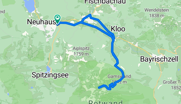
Neuhaus zum Soinsee, Großtiefenthalalm
A cycling route starting in Fischbachau, Bavaria, Germany.
Overview
About this route
Zum Soinsee zuerst konstanter Anstieg, gegen Ende kommen ein paar steile Rampen, das letzte Stück vorm Soinsee kann man auch schieben :-) Aber mit Blick auf den Wendelstein geht auch das. Zum Schluss beeindrucken die Felswände von Rotwand, Miesing, Ruchenköpfe
- -:--
- Duration
- 27.5 km
- Distance
- 908 m
- Ascent
- 906 m
- Descent
- ---
- Avg. speed
- 1,511 m
- Max. altitude
Route quality
Waytypes & surfaces along the route
Waytypes
Track
19.5 km
(71 %)
Quiet road
4.1 km
(15 %)
Surfaces
Paved
12.3 km
(45 %)
Unpaved
14.8 km
(54 %)
Asphalt
12.2 km
(44 %)
Unpaved (undefined)
5.9 km
(22 %)
Route highlights
Points of interest along the route

Point of interest after 12.3 km
Wendelstein von Schellenbergalm

Point of interest after 13.1 km
Soinsee mit Ruchenköpfe

Point of interest after 14.2 km
Großtiefenthalalm mit Rotwand

Point of interest after 15.7 km
Schellenbergalm mit Wendelstein
Continue with Bikemap
Use, edit, or download this cycling route
You would like to ride Neuhaus zum Soinsee, Großtiefenthalalm or customize it for your own trip? Here is what you can do with this Bikemap route:
Free features
- Save this route as favorite or in collections
- Copy & plan your own version of this route
- Sync your route with Garmin or Wahoo
Premium features
Free trial for 3 days, or one-time payment. More about Bikemap Premium.
- Navigate this route on iOS & Android
- Export a GPX / KML file of this route
- Create your custom printout (try it for free)
- Download this route for offline navigation
Discover more Premium features.
Get Bikemap PremiumFrom our community
Other popular routes starting in Fischbachau
 08-Jaegerkamp-Schneeschuh
- Distance
- 11.6 km
- Ascent
- 694 m
- Descent
- 697 m
- Location
- Fischbachau, Bavaria, Germany
 Rund um den Schweinsberg
- Distance
- 10.2 km
- Ascent
- 861 m
- Descent
- 861 m
- Location
- Fischbachau, Bavaria, Germany
 vom Spitzingsee - ums ht. Sonnwendjoch - über den Elendsattel
- Distance
- 43.9 km
- Ascent
- 1,387 m
- Descent
- 1,488 m
- Location
- Fischbachau, Bavaria, Germany
 Von Neuhaus über den Soinsee zum Rotwandhaus
- Distance
- 29.4 km
- Ascent
- 1,059 m
- Descent
- 1,059 m
- Location
- Fischbachau, Bavaria, Germany
 Leitzachtaler Bergblickweg
- Distance
- 12.2 km
- Ascent
- 198 m
- Descent
- 176 m
- Location
- Fischbachau, Bavaria, Germany
 Rund um die Rotwand (ab/bis Neuhaus)
- Distance
- 40.4 km
- Ascent
- 1,004 m
- Descent
- 1,004 m
- Location
- Fischbachau, Bavaria, Germany
 Tegernsee Tour über Bad Feilnbach und Spitzingsee
- Distance
- 87.7 km
- Ascent
- 1,061 m
- Descent
- 1,062 m
- Location
- Fischbachau, Bavaria, Germany
 Übern Spitzingsattel zur Oberen Schönfeldalm
- Distance
- 19.6 km
- Ascent
- 870 m
- Descent
- 844 m
- Location
- Fischbachau, Bavaria, Germany
Open it in the app