

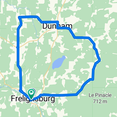
Frelighsburg - Montgomery - Smugglers
A cycling route starting in Bedford, Quebec, Canada.
Overview
About this route
Frelighsburgh - 237 sud (Principale)
Chemin de Richford (Joy Hill)
Douanes
Pinnacle Road (devient River St à Richford)
Main St (105)
Troy St (105 East)
South Richford Road (devient Fuller Bridge Road)
Montgomery
Main St (118)
118 Sud (Montgomery Ctr)
109 West (Belvedere Ctr, Waterville)
Vt Route 15 -> Jeffersonville
Village Jeffersonville
108 Sud vers Smuggler's Nothc/Stowe
au sommet demi-tour et descente
Village Jeffersonville
108 Nord (Bakersfield, West Enosburg)
105 West (South Franklin)
236 Nord (State Park Road)
vers East Franklin (108 Nord)
Douanes
237 Nord vers Frelighsburg
- -:--
- Duration
- 152.2 km
- Distance
- 2,083 m
- Ascent
- 2,059 m
- Descent
- ---
- Avg. speed
- 686 m
- Max. altitude

Route quality
Waytypes & surfaces along the route
Waytypes
Road
25.9 km
(17 %)
Quiet road
3 km
(2 %)
Surfaces
Paved
146.1 km
(96 %)
Unpaved
1.5 km
(1 %)
Asphalt
134 km
(88 %)
Paved (undefined)
12.2 km
(8 %)
Continue with Bikemap
Use, edit, or download this cycling route
You would like to ride Frelighsburg - Montgomery - Smugglers or customize it for your own trip? Here is what you can do with this Bikemap route:
Free features
- Save this route as favorite or in collections
- Copy & plan your own version of this route
- Split it into stages to create a multi-day tour
- Sync your route with Garmin or Wahoo
Premium features
Free trial for 3 days, or one-time payment. More about Bikemap Premium.
- Navigate this route on iOS & Android
- Export a GPX / KML file of this route
- Create your custom printout (try it for free)
- Download this route for offline navigation
Discover more Premium features.
Get Bikemap PremiumFrom our community
Other popular routes starting in Bedford

 Rue Principale, Frelighsburg to Rue Principale, Frelighsburg
- Distance
- 33.9 km
- Ascent
- 393 m
- Descent
- 391 m
- Location
- Bedford, Quebec, Canada
 Notre Dame de Stanbridge, Frelighsburg, Mystic
- Distance
- 78.4 km
- Ascent
- 286 m
- Descent
- 285 m
- Location
- Bedford, Quebec, Canada
 Frelighsburg, Scenic, North Troy, 105, Montgomery 110 km
- Distance
- 110.9 km
- Ascent
- 1,092 m
- Descent
- 1,092 m
- Location
- Bedford, Quebec, Canada
 Vallée noire intermédiaire
- Distance
- 94.7 km
- Ascent
- 457 m
- Descent
- 458 m
- Location
- Bedford, Quebec, Canada
 circuit du Patrimoine - Bedford
- Distance
- 42 km
- Ascent
- 295 m
- Descent
- 293 m
- Location
- Bedford, Quebec, Canada
 Rang de l'Église S, St-Ignace-de-Stanbridge à Marsh Farm Rd, Enosburg Falls
- Distance
- 41.9 km
- Ascent
- 387 m
- Descent
- 299 m
- Location
- Bedford, Quebec, Canada
 Tournée au Vermont (1)
- Distance
- 57.1 km
- Ascent
- 255 m
- Descent
- 255 m
- Location
- Bedford, Quebec, Canada
Open it in the app