

Mainflingen - Hahnenkamm - Mainflingen - nette Runde
A cycling route starting in Seligenstadt, Hesse, Germany.
Overview
About this route
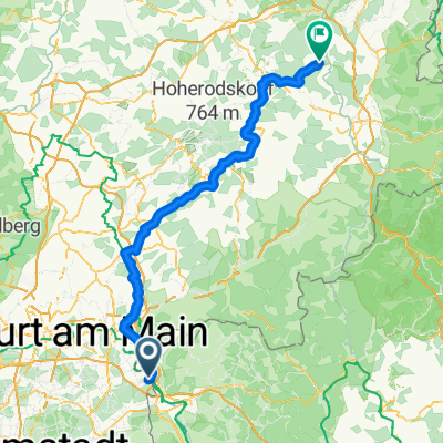
Start in Mainflingen, then take the Schranke-Schranke path 'Buckelnuff' via the Hohl to the Hahnenkamm. At the top, a bit along the ridge, steep descent, semi-alpine climb again, catch your breath, and comfortably return to Mainflingen.
- -:--
- Duration
- 13.3 km
- Distance
- 480 m
- Ascent
- 245 m
- Descent
- ---
- Avg. speed
- ---
- Max. altitude
Continue with Bikemap
Use, edit, or download this cycling route
You would like to ride Mainflingen - Hahnenkamm - Mainflingen - nette Runde or customize it for your own trip? Here is what you can do with this Bikemap route:
Free features
- Save this route as favorite or in collections
- Copy & plan your own version of this route
- Sync your route with Garmin or Wahoo
Premium features
Free trial for 3 days, or one-time payment. More about Bikemap Premium.
- Navigate this route on iOS & Android
- Export a GPX / KML file of this route
- Create your custom printout (try it for free)
- Download this route for offline navigation
Discover more Premium features.
Get Bikemap PremiumFrom our community
Other popular routes starting in Seligenstadt
 Große Spessartrunde
- Distance
- 40.4 km
- Ascent
- 469 m
- Descent
- 423 m
- Location
- Seligenstadt, Hesse, Germany
 Fasanerierunde
- Distance
- 30.6 km
- Ascent
- 132 m
- Descent
- 126 m
- Location
- Seligenstadt, Hesse, Germany
 An der Lache, Seligenstadt nach Ludwigstraße, Rodgau
- Distance
- 7.1 km
- Ascent
- 111 m
- Descent
- 86 m
- Location
- Seligenstadt, Hesse, Germany
 Rund um Seligenstadt
- Distance
- 33.2 km
- Ascent
- 117 m
- Descent
- 117 m
- Location
- Seligenstadt, Hesse, Germany
 Mainflingen - Schlitz
- Distance
- 124.6 km
- Ascent
- 1,072 m
- Descent
- 948 m
- Location
- Seligenstadt, Hesse, Germany
 Seligenstadt - Budenheim
- Distance
- 82 km
- Ascent
- 168 m
- Descent
- 194 m
- Location
- Seligenstadt, Hesse, Germany
 Mainflingen - Hahnenkamm - Mainflingen - nette Runde
- Distance
- 13.3 km
- Ascent
- 480 m
- Descent
- 245 m
- Location
- Seligenstadt, Hesse, Germany
 Hörstein Plattenberg, Pfahlloch, Weinberge und D - Weg
- Distance
- 35.2 km
- Ascent
- 572 m
- Descent
- 574 m
- Location
- Seligenstadt, Hesse, Germany
Open it in the app