

Grießenkar - Mayrdörfl
A cycling route starting in Flachau, Salzburg, Austria.
Overview
About this route
Characteristics:
MTB tour mostly on good gravel roads with a long climb at the start of the tour. The highlight of the tour is the long descent of almost 1,000 meters in elevation from Grießenkar to Mayrdörfl.
Starting & End Point:
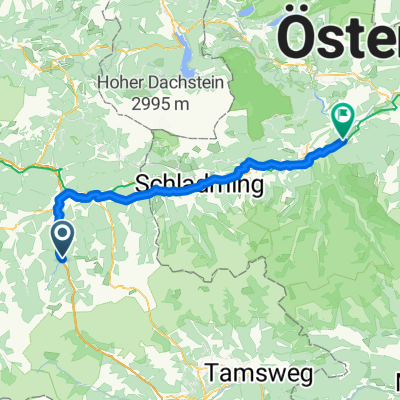
Tourist information Flachau
Route Description:
Start at the Flachau tourist office - along the Flachauer Straße heading downstream - after 500 meters turn left onto Grießenkarweg (near Hotel Pongauerhof), long climb on forest road up to Grießenkar (refreshment options: Waldgasthof, Jandlalm, Hofalm, Latschenhof - please note seasonal opening times!) - after Jandlalm turn right towards Almstadl and Rupertisee - at km 8.7 turn right towards Wagrain - long descent to Mayrdörfl (parking at the Rote Achter gondola lift) - from Mayrdörfl turn right back to the starting point in Flachau
(cloned from route 926059)
- -:--
- Duration
- 23.7 km
- Distance
- 891 m
- Ascent
- 891 m
- Descent
- ---
- Avg. speed
- ---
- Max. altitude
Route highlights
Points of interest along the route
Point of interest after 4.8 km
Waldgasthof - Möglichkeit zur Einkehr
Point of interest after 7.4 km
Latschenhof - Möglichkeit zur Einkehr
Photo after 8.2 km
Atemberaubender Rundumblick auf die Bergwelt
Continue with Bikemap
Use, edit, or download this cycling route
You would like to ride Grießenkar - Mayrdörfl or customize it for your own trip? Here is what you can do with this Bikemap route:
Free features
- Save this route as favorite or in collections
- Copy & plan your own version of this route
- Sync your route with Garmin or Wahoo
Premium features
Free trial for 3 days, or one-time payment. More about Bikemap Premium.
- Navigate this route on iOS & Android
- Export a GPX / KML file of this route
- Create your custom printout (try it for free)
- Download this route for offline navigation
Discover more Premium features.
Get Bikemap PremiumFrom our community
Other popular routes starting in Flachau
 Wiestal - Salzkammergut
- Distance
- 181.7 km
- Ascent
- 1,576 m
- Descent
- 1,576 m
- Location
- Flachau, Salzburg, Austria
 Ennstalradweg vgo reisen
- Distance
- 36.1 km
- Ascent
- 73 m
- Descent
- 341 m
- Location
- Flachau, Salzburg, Austria
 Hüttau - Hochgründeck - Wagrain
- Distance
- 60.3 km
- Ascent
- 1,330 m
- Descent
- 1,330 m
- Location
- Flachau, Salzburg, Austria
 Mühlbach - Dienten - Schwarzach
- Distance
- 101.9 km
- Ascent
- 1,205 m
- Descent
- 1,205 m
- Location
- Flachau, Salzburg, Austria
 1. Flachau nach Öblarn
- Distance
- 66.4 km
- Ascent
- 888 m
- Descent
- 1,242 m
- Location
- Flachau, Salzburg, Austria
 Frauenalm - Baierwald - Mayrdörfl
- Distance
- 32.4 km
- Ascent
- 1,006 m
- Descent
- 1,006 m
- Location
- Flachau, Salzburg, Austria
 Etappe 1 Ennstalradweg
- Distance
- 82.7 km
- Ascent
- 74 m
- Descent
- 466 m
- Location
- Flachau, Salzburg, Austria
 STONEMAN TAURISTA
- Distance
- 124.5 km
- Ascent
- 4,385 m
- Descent
- 4,382 m
- Location
- Flachau, Salzburg, Austria
Open it in the app