

MIKE MYERS MOTORCYCLE MADNESS ROUTE
A cycling route starting in Westlake, Louisiana, United States.
Overview
About this route
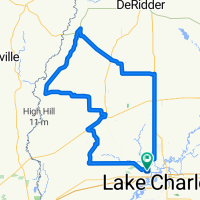
START: NEW LIFE CHURCH OF WESTLAKE
1010 Shady Ln, Westlake, LA STOP 1: BROOKSHIRE BROTHERS in DeQuincy W. 4th St, DeQuincy, LA STOP 2: MERRYVILLE TRUCK STOP 11459 US-190, Merryville, LA STOP 3: GILLIS FOOD MART 6191 N Hwy 171, Lake Charles, LA END: NEW LIFE CHURCH OF WESTLAKE 1010 Shady Ln, Westlake, LA- -:--
- Duration
- 236.3 km
- Distance
- 139 m
- Ascent
- 140 m
- Descent
- ---
- Avg. speed
- ---
- Max. altitude
Route quality
Waytypes & surfaces along the route
Waytypes
Busy road
127.3 km
(54 %)
Quiet road
38 km
(16 %)
Surfaces
Paved
0.2 km
(<1 %)
Asphalt
0.2 km
(<1 %)
Undefined
236.1 km
(100 %)
Route highlights
Points of interest along the route
Point of interest after 54.8 km
BROOKSHIRE BROTHERS WEST 4TH ST DEQUINCY, LA
Point of interest after 149.4 km
MERRYVILLE TRUCK STOP 11459 US-190 Merryville, LA 70653
Point of interest after 218.9 km
Gillis Food Mart 6191 N Hwy 171 Lake Charles, LA 70611
Point of interest after 218.9 km
Gillis Food Mart 6191 N Hwy 171 Lake Charles, LA 70611
Point of interest after 236 km
START/END NEW LIFE CHURCH 1010 Shady Ln Westlake, LA
Continue with Bikemap
Use, edit, or download this cycling route
You would like to ride MIKE MYERS MOTORCYCLE MADNESS ROUTE or customize it for your own trip? Here is what you can do with this Bikemap route:
Free features
- Save this route as favorite or in collections
- Copy & plan your own version of this route
- Split it into stages to create a multi-day tour
- Sync your route with Garmin or Wahoo
Premium features
Free trial for 3 days, or one-time payment. More about Bikemap Premium.
- Navigate this route on iOS & Android
- Export a GPX / KML file of this route
- Create your custom printout (try it for free)
- Download this route for offline navigation
Discover more Premium features.
Get Bikemap PremiumFrom our community
Other popular routes starting in Westlake
 MIKE MYERS MOTORCYCLE MADNESS ROUTE
- Distance
- 236.3 km
- Ascent
- 139 m
- Descent
- 140 m
- Location
- Westlake, Louisiana, United States
 Sam Houston Jones State Park Road, Lake Charles to Sam Houston Jones State Park Road, Lake Charles
- Distance
- 4.6 km
- Ascent
- 6 m
- Descent
- 7 m
- Location
- Westlake, Louisiana, United States
 152 Marine St, Lake Charles to 2710 Lodden St, Lake Charles
- Distance
- 12.4 km
- Ascent
- 35 m
- Descent
- 26 m
- Location
- Westlake, Louisiana, United States
 Moderate route in Westlake
- Distance
- 7.4 km
- Ascent
- 20 m
- Descent
- 20 m
- Location
- Westlake, Louisiana, United States
Open it in the app