
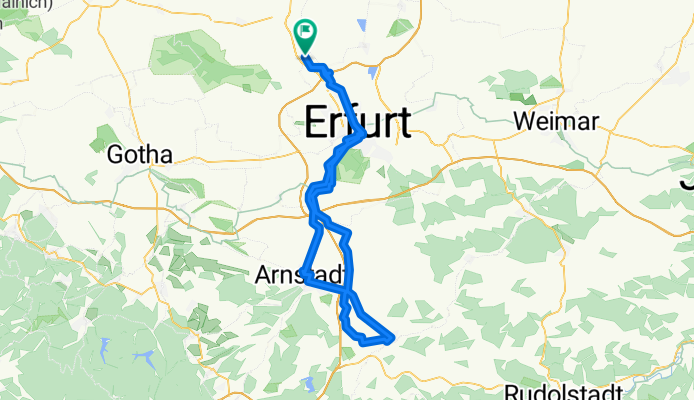
Elxleben - Erfurt - Arnstadt - Stadtilm - Erfurt - Elxleben
A cycling route starting in Elxleben, Free State of Thuringia, Germany.
Overview
About this route
Die Tour startete in Elxleben an der Gera und ging zu erst zum Erfurter Hauptbahnhof. Von da aus startete die 21.Regenbogentour über Arnstadt nach Stadtilm.Die Rücktour führte über Niederwillingen-Hausen-Marlishausen (Mühlberg-Stadtilm-Radweg) - Kirchheim-Eischleben-Molsdorf (Gera-Radweg)-Bischleben-Hochheim-Erfurt-Gispersleben-Kühnhausen-Elxleben
- -:--
- Duration
- 93.1 km
- Distance
- 292 m
- Ascent
- 290 m
- Descent
- ---
- Avg. speed
- ---
- Max. altitude

Route quality
Waytypes & surfaces along the route
Waytypes
Road
24.3 km
(26 %)
Path
18.9 km
(20 %)
Surfaces
Paved
69.9 km
(75 %)
Unpaved
10.8 km
(12 %)
Asphalt
59.2 km
(64 %)
Gravel
5.7 km
(6 %)
Continue with Bikemap
Use, edit, or download this cycling route
You would like to ride Elxleben - Erfurt - Arnstadt - Stadtilm - Erfurt - Elxleben or customize it for your own trip? Here is what you can do with this Bikemap route:
Free features
- Save this route as favorite or in collections
- Copy & plan your own version of this route
- Split it into stages to create a multi-day tour
- Sync your route with Garmin or Wahoo
Premium features
Free trial for 3 days, or one-time payment. More about Bikemap Premium.
- Navigate this route on iOS & Android
- Export a GPX / KML file of this route
- Create your custom printout (try it for free)
- Download this route for offline navigation
Discover more Premium features.
Get Bikemap PremiumFrom our community
Other popular routes starting in Elxleben
 27.08.2019
- Distance
- 38.8 km
- Ascent
- 44 m
- Descent
- 48 m
- Location
- Elxleben, Free State of Thuringia, Germany
 Ausfahrt durch Erfurt 19.07.17
- Distance
- 18.2 km
- Ascent
- 27 m
- Descent
- 27 m
- Location
- Elxleben, Free State of Thuringia, Germany
 22.08.2018
- Distance
- 43.1 km
- Ascent
- 32 m
- Descent
- 43 m
- Location
- Elxleben, Free State of Thuringia, Germany
 200km Elxleben - Artern - Freyburg - Weimar Elxleben
- Distance
- 201.7 km
- Ascent
- 948 m
- Descent
- 948 m
- Location
- Elxleben, Free State of Thuringia, Germany
 Friedhofstraße 52, Erfurt nach Friedhofstraße 52, Erfurt
- Distance
- 29.4 km
- Ascent
- 290 m
- Descent
- 296 m
- Location
- Elxleben, Free State of Thuringia, Germany
 Elxleben - Frömmstedt (Teil:Tour de Frömmschdt) und zurück
- Distance
- 99.3 km
- Ascent
- 113 m
- Descent
- 113 m
- Location
- Elxleben, Free State of Thuringia, Germany
 Elxleben - Riechheim und zurück
- Distance
- 91.6 km
- Ascent
- 556 m
- Descent
- 554 m
- Location
- Elxleben, Free State of Thuringia, Germany
 Radrunde 26.08.17
- Distance
- 24.4 km
- Ascent
- 24 m
- Descent
- 22 m
- Location
- Elxleben, Free State of Thuringia, Germany
Open it in the app