Nº19 Marcha IV Catlike 2012 Titoabuelito
- 137.5 km
- 2,122 m
- 2,122 m
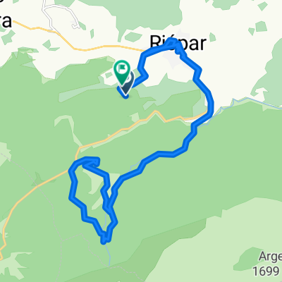
- Riópar, Castille-La Mancha, Spain
A cycling route starting in Riópar, Castille-La Mancha, Spain.
Overview
RIOPAR, EL LAMINADOR, ALTO DEL PERALEJO DE 2ª CATEGORIA DISTANCIA 5,13 KLM DESNIVEI MEDIO 4,2 %, FUENTE HIGUERA, MOLINICOS, ARROYO MOROTE, ALTO DE BOCHE DE 2ª CATEGOTIA DISTANCIA 6,05 KLM DESNIVEL MEDIO 5,7 %, BOCHE, YESTE, LA GRAYA, ALTO DE LA BORRIQUETA DE 1ª CATEGORIA DISTANCIA 10.44 DESNIVEL MEDIO 6,9% Y 1356 M S N M, SEGE, ALTO DE LA VICARIA DE 3ª CATEGORIA DISTANCIA 5,18 KLM DESNIVEL MEDIO 4,0 %, MOLINICOS, ALTO DEL PARDAL DE 2ª CATEGORIA DISTANCIA 14,09 KLM DESNIVEL MEDIO 3,1 %, RIOPAR, 141,89 KLM,
created this 10 years ago
Route quality
Road
46.8 km
(33 %)
Quiet road
17 km
(12 %)
Undefined
78.1 km
(55 %)
Paved
83.7 km
(59 %)
Asphalt
83.7 km
(59 %)
Undefined
58.2 km
(41 %)
Continue with Bikemap
You would like to ride CATLIKE 2015 or customize it for your own trip? Here is what you can do with this Bikemap route:
Free trial for 3 days, or one-time payment. More about Bikemap Premium.
Discover more Premium features.
Get Bikemap PremiumFrom our community
Open it in the app