

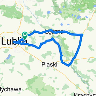
Szlak Gminy Niemce - zmodyfikowany
A cycling route starting in Jakubowice Murowane, Lublin Voivodeship, Poland.
Overview
About this route
Changed trail of Niemce municipality including a section of trails from Jastków municipality
- -:--
- Duration
- 50 km
- Distance
- 149 m
- Ascent
- 149 m
- Descent
- ---
- Avg. speed
- ---
- Max. altitude

Route quality
Waytypes & surfaces along the route
Waytypes
Quiet road
19 km
(38 %)
Track
12 km
(24 %)
Surfaces
Paved
35.5 km
(71 %)
Unpaved
11.5 km
(23 %)
Asphalt
35.5 km
(71 %)
Ground
6 km
(12 %)
Continue with Bikemap
Use, edit, or download this cycling route
You would like to ride Szlak Gminy Niemce - zmodyfikowany or customize it for your own trip? Here is what you can do with this Bikemap route:
Free features
- Save this route as favorite or in collections
- Copy & plan your own version of this route
- Sync your route with Garmin or Wahoo
Premium features
Free trial for 3 days, or one-time payment. More about Bikemap Premium.
- Navigate this route on iOS & Android
- Export a GPX / KML file of this route
- Create your custom printout (try it for free)
- Download this route for offline navigation
Discover more Premium features.
Get Bikemap PremiumFrom our community
Other popular routes starting in Jakubowice Murowane
 Parczew 2017 dzień 2
- Distance
- 82.2 km
- Ascent
- 80 m
- Descent
- 109 m
- Location
- Jakubowice Murowane, Lublin Voivodeship, Poland
 2010.06.04
- Distance
- 107.5 km
- Ascent
- 102 m
- Descent
- 105 m
- Location
- Jakubowice Murowane, Lublin Voivodeship, Poland
 Droga Krajowa do Turystyczna 33D
- Distance
- 12.8 km
- Ascent
- 314 m
- Descent
- 249 m
- Location
- Jakubowice Murowane, Lublin Voivodeship, Poland
 wycieczka
- Distance
- 67.9 km
- Ascent
- 166 m
- Descent
- 166 m
- Location
- Jakubowice Murowane, Lublin Voivodeship, Poland
 Koncpecja szlaku stacja PKP Ciecierzyn-szl. niebieski
- Distance
- 2.3 km
- Ascent
- 0 m
- Descent
- 21 m
- Location
- Jakubowice Murowane, Lublin Voivodeship, Poland
 Dys-Firlej przez Lubartów
- Distance
- 75.5 km
- Ascent
- 151 m
- Descent
- 149 m
- Location
- Jakubowice Murowane, Lublin Voivodeship, Poland
 Szlak Gminy Niemce - zmodyfikowany
- Distance
- 50 km
- Ascent
- 149 m
- Descent
- 149 m
- Location
- Jakubowice Murowane, Lublin Voivodeship, Poland
 Winterpacking 2024
- Distance
- 116.5 km
- Ascent
- 693 m
- Descent
- 672 m
- Location
- Jakubowice Murowane, Lublin Voivodeship, Poland
Open it in the app