

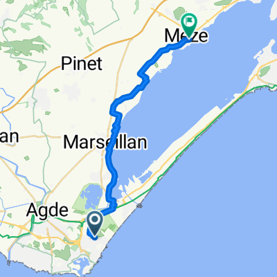
Marseillan Plage Agde
A cycling route starting in Le Cap D'Agde, Occitanie, France.
Overview
About this route
Marseillan Plage Cape D'agde Grau d'Agde
- -:--
- Duration
- 28.4 km
- Distance
- 45 m
- Ascent
- 44 m
- Descent
- ---
- Avg. speed
- ---
- Max. altitude
Continue with Bikemap
Use, edit, or download this cycling route
You would like to ride Marseillan Plage Agde or customize it for your own trip? Here is what you can do with this Bikemap route:
Free features
- Save this route as favorite or in collections
- Copy & plan your own version of this route
- Sync your route with Garmin or Wahoo
Premium features
Free trial for 3 days, or one-time payment. More about Bikemap Premium.
- Navigate this route on iOS & Android
- Export a GPX / KML file of this route
- Create your custom printout (try it for free)
- Download this route for offline navigation
Discover more Premium features.
Get Bikemap PremiumFrom our community
Other popular routes starting in Le Cap D'Agde
 tour de l'étang de thau
- Distance
- 66.4 km
- Ascent
- 80 m
- Descent
- 80 m
- Location
- Le Cap D'Agde, Occitanie, France
 Tour de France 2009, Etappe 5 - 196,5 km
- Distance
- 196.5 km
- Ascent
- 503 m
- Descent
- 489 m
- Location
- Le Cap D'Agde, Occitanie, France
 agde 2
- Distance
- 7 km
- Ascent
- 16 m
- Descent
- 3 m
- Location
- Le Cap D'Agde, Occitanie, France
 Beziers
- Distance
- 32.2 km
- Ascent
- 86 m
- Descent
- 26 m
- Location
- Le Cap D'Agde, Occitanie, France
 The canals to Vias one
- Distance
- 33.3 km
- Ascent
- 47 m
- Descent
- 47 m
- Location
- Le Cap D'Agde, Occitanie, France
 Le Cap d'Agde - Toulouse
- Distance
- 197.4 km
- Ascent
- 365 m
- Descent
- 223 m
- Location
- Le Cap D'Agde, Occitanie, France
 The Meze one
- Distance
- 21 km
- Ascent
- 66 m
- Descent
- 59 m
- Location
- Le Cap D'Agde, Occitanie, France
 Etang de Thau
- Distance
- 78.9 km
- Ascent
- 125 m
- Descent
- 124 m
- Location
- Le Cap D'Agde, Occitanie, France
Open it in the app