

KAJKAVIJANA 2015 trening Sljeme
A cycling route starting in Selnica, Krapina-Zagorje County, Croatia.
Overview
About this route
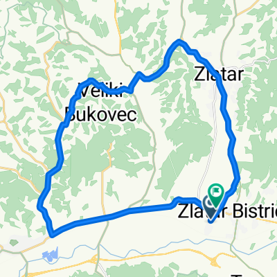
Zagorje section of training for Kajkavijana 2015
Zlatar Bistrica - Oroslavlje - Sljeme - Gorščica - Marija Bistrica - Zlatar Bistrica
- -:--
- Duration
- 72.8 km
- Distance
- 936 m
- Ascent
- 943 m
- Descent
- ---
- Avg. speed
- ---
- Max. altitude

Continue with Bikemap
Use, edit, or download this cycling route
You would like to ride KAJKAVIJANA 2015 trening Sljeme or customize it for your own trip? Here is what you can do with this Bikemap route:
Free features
- Save this route as favorite or in collections
- Copy & plan your own version of this route
- Sync your route with Garmin or Wahoo
Premium features
Free trial for 3 days, or one-time payment. More about Bikemap Premium.
- Navigate this route on iOS & Android
- Export a GPX / KML file of this route
- Create your custom printout (try it for free)
- Download this route for offline navigation
Discover more Premium features.
Get Bikemap PremiumFrom our community
Other popular routes starting in Selnica
 Neke
Neke- Distance
- 23.4 km
- Ascent
- 170 m
- Descent
- 177 m
- Location
- Selnica, Krapina-Zagorje County, Croatia
 Kružna ruta OŠ G. Stubica - brana Burnjak - G. Stubica
- Distance
- 11.6 km
- Ascent
- 231 m
- Descent
- 227 m
- Location
- Selnica, Krapina-Zagorje County, Croatia
 Stubica / #2
- Distance
- 41.9 km
- Ascent
- 1,412 m
- Descent
- 1,323 m
- Location
- Selnica, Krapina-Zagorje County, Croatia
 staza
staza- Distance
- 33.9 km
- Ascent
- 195 m
- Descent
- 193 m
- Location
- Selnica, Krapina-Zagorje County, Croatia
 Zagorje križ 70 km
- Distance
- 68.9 km
- Ascent
- 189 m
- Descent
- 189 m
- Location
- Selnica, Krapina-Zagorje County, Croatia
 Gornja Stubica - Hunjka - Sljeme - Hunjka - Gorscica - Gornja Stubica
- Distance
- 37.7 km
- Ascent
- 913 m
- Descent
- 905 m
- Location
- Selnica, Krapina-Zagorje County, Croatia
 G.Stubica-M.Bistriza-Laz-PlaninaDonja-PlaninaGornja-G.Stubica
- Distance
- 38.9 km
- Ascent
- 658 m
- Descent
- 652 m
- Location
- Selnica, Krapina-Zagorje County, Croatia
 22.6.2016.
- Distance
- 16.3 km
- Ascent
- 199 m
- Descent
- 195 m
- Location
- Selnica, Krapina-Zagorje County, Croatia
Open it in the app