

Labergement-Sainte-Marie_Troyes
A cycling route starting in Jougne, Bourgogne-Franche-Comté, France.
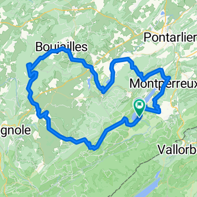
Overview
About this route
Possible Second Route from Zurich to Paris
- -:--
- Duration
- 287 km
- Distance
- 1,119 m
- Ascent
- 1,819 m
- Descent
- ---
- Avg. speed
- ---
- Max. altitude
Route quality
Waytypes & surfaces along the route
Waytypes
Road
169.3 km
(59 %)
Quiet road
48.8 km
(17 %)
Surfaces
Paved
94.7 km
(33 %)
Asphalt
94.7 km
(33 %)
Undefined
192.3 km
(67 %)
Continue with Bikemap
Use, edit, or download this cycling route
You would like to ride Labergement-Sainte-Marie_Troyes or customize it for your own trip? Here is what you can do with this Bikemap route:
Free features
- Save this route as favorite or in collections
- Copy & plan your own version of this route
- Split it into stages to create a multi-day tour
- Sync your route with Garmin or Wahoo
Premium features
Free trial for 3 days, or one-time payment. More about Bikemap Premium.
- Navigate this route on iOS & Android
- Export a GPX / KML file of this route
- Create your custom printout (try it for free)
- Download this route for offline navigation
Discover more Premium features.
Get Bikemap PremiumFrom our community
Other popular routes starting in Jougne
 Domingo de Manhattan
- Distance
- 62.1 km
- Ascent
- 258 m
- Descent
- 833 m
- Location
- Jougne, Bourgogne-Franche-Comté, France
 Lac de Remory-Mouthe
- Distance
- 46.7 km
- Ascent
- 655 m
- Descent
- 602 m
- Location
- Jougne, Bourgogne-Franche-Comté, France
 Remorayaoût2025
- Distance
- 109.3 km
- Ascent
- 1,636 m
- Descent
- 1,628 m
- Location
- Jougne, Bourgogne-Franche-Comté, France
 lac st-point tour
- Distance
- 20.1 km
- Ascent
- 177 m
- Descent
- 163 m
- Location
- Jougne, Bourgogne-Franche-Comté, France
 Lac de Remoray-Mouthe
- Distance
- 48.4 km
- Ascent
- 723 m
- Descent
- 649 m
- Location
- Jougne, Bourgogne-Franche-Comté, France
 Jura Val de Mouthe
- Distance
- 30 km
- Ascent
- 429 m
- Descent
- 430 m
- Location
- Jougne, Bourgogne-Franche-Comté, France
 around Saint-point lake
- Distance
- 23.7 km
- Ascent
- 139 m
- Descent
- 122 m
- Location
- Jougne, Bourgogne-Franche-Comté, France
 Grande Traversée du Jura - Etape 3 : Métabief / Les Rousses (65 km / D+ 1300 m)
- Distance
- 64.9 km
- Ascent
- 1,028 m
- Descent
- 887 m
- Location
- Jougne, Bourgogne-Franche-Comté, France
Open it in the app