

Kongerittet MTB
A cycling route starting in Teigebyen, Akershus, Norway.
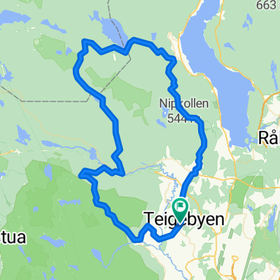
Overview
About this route
Start og mål Teigebyen Nannastad Grus, asfalt
(cloned from route 2652692)- -:--
- Duration
- 66.7 km
- Distance
- 837 m
- Ascent
- 837 m
- Descent
- ---
- Avg. speed
- ---
- Max. altitude

Route quality
Waytypes & surfaces along the route
Waytypes
Quiet road
49.4 km
(74 %)
Access road
6.7 km
(10 %)
Surfaces
Paved
9.3 km
(14 %)
Unpaved
13.3 km
(20 %)
Asphalt
9.3 km
(14 %)
Unpaved (undefined)
8 km
(12 %)
Continue with Bikemap
Use, edit, or download this cycling route
You would like to ride Kongerittet MTB or customize it for your own trip? Here is what you can do with this Bikemap route:
Free features
- Save this route as favorite or in collections
- Copy & plan your own version of this route
- Sync your route with Garmin or Wahoo
Premium features
Free trial for 3 days, or one-time payment. More about Bikemap Premium.
- Navigate this route on iOS & Android
- Export a GPX / KML file of this route
- Create your custom printout (try it for free)
- Download this route for offline navigation
Discover more Premium features.
Get Bikemap PremiumFrom our community
Other popular routes starting in Teigebyen
 Oslo-Bergen
- Distance
- 825.7 km
- Ascent
- 5,245 m
- Descent
- 5,396 m
- Location
- Teigebyen, Akershus, Norway
 Norwegentour2007_01
- Distance
- 37.2 km
- Ascent
- 459 m
- Descent
- 355 m
- Location
- Teigebyen, Akershus, Norway
 Pętla dookoła Norwegii 2012
- Distance
- 1,935.3 km
- Ascent
- 9,779 m
- Descent
- 9,779 m
- Location
- Teigebyen, Akershus, Norway
 Easy ride in Jessheim
- Distance
- 15.7 km
- Ascent
- 141 m
- Descent
- 140 m
- Location
- Teigebyen, Akershus, Norway
 Route Norway day 1
- Distance
- 66.7 km
- Ascent
- 756 m
- Descent
- 334 m
- Location
- Teigebyen, Akershus, Norway
 2011.08-09 Oslo - Molde - Bergen
- Distance
- 2,223.1 km
- Ascent
- 7,026 m
- Descent
- 7,176 m
- Location
- Teigebyen, Akershus, Norway
 Snel fotoboek
- Distance
- 2,591.1 km
- Ascent
- 2,638 m
- Descent
- 2,564 m
- Location
- Teigebyen, Akershus, Norway
 Kongerittet MTB
- Distance
- 61 km
- Ascent
- 785 m
- Descent
- 785 m
- Location
- Teigebyen, Akershus, Norway
Open it in the app