

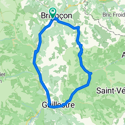
Col du Galibier
A cycling route starting in Briançon, Provence-Alpes-Côte d'Azur Region, France.
Overview
About this route
Galibier da Briancon e ritorno passando per il Lautaret
- -:--
- Duration
- 76.5 km
- Distance
- 1,389 m
- Ascent
- 1,389 m
- Descent
- ---
- Avg. speed
- ---
- Max. altitude
Route quality
Waytypes & surfaces along the route
Waytypes
Busy road
66.2 km
(87 %)
Quiet road
7 km
(9 %)
Surfaces
Paved
65.8 km
(86 %)
Unpaved
0.1 km
(<1 %)
Asphalt
65.5 km
(86 %)
Paved (undefined)
0.3 km
(<1 %)
Route highlights
Points of interest along the route
Point of interest after 29.4 km
Col du Lautaret 2058m
Point of interest after 38.2 km
Col du Galibier 2642m
Continue with Bikemap
Use, edit, or download this cycling route
You would like to ride Col du Galibier or customize it for your own trip? Here is what you can do with this Bikemap route:
Free features
- Save this route as favorite or in collections
- Copy & plan your own version of this route
- Sync your route with Garmin or Wahoo
Premium features
Free trial for 3 days, or one-time payment. More about Bikemap Premium.
- Navigate this route on iOS & Android
- Export a GPX / KML file of this route
- Create your custom printout (try it for free)
- Download this route for offline navigation
Discover more Premium features.
Get Bikemap PremiumFrom our community
Other popular routes starting in Briançon
 briancon-izoard
- Distance
- 20.4 km
- Ascent
- 1,201 m
- Descent
- 155 m
- Location
- Briançon, Provence-Alpes-Côte d'Azur Region, France
 5-Tag_Briancon-Saluzzo
- Distance
- 125.3 km
- Ascent
- 2,490 m
- Descent
- 3,355 m
- Location
- Briançon, Provence-Alpes-Côte d'Azur Region, France
![Briançon [Col d'Izoard] loop](https://media.bikemap.net/routes/4330868/staticmaps/in_dc7e89bc-1ec1-4a7f-a59e-af212601d962_400x400_bikemap-2021-3D-static.png) Briançon [Col d'Izoard] loop
Briançon [Col d'Izoard] loop- Distance
- 94.2 km
- Ascent
- 1,814 m
- Descent
- 1,814 m
- Location
- Briançon, Provence-Alpes-Côte d'Azur Region, France
 Col du Granon kör
- Distance
- 66.4 km
- Ascent
- 2,625 m
- Descent
- 2,625 m
- Location
- Briançon, Provence-Alpes-Côte d'Azur Region, France
 Westalpen Etappe 09 - Briancon
- Distance
- 83.5 km
- Ascent
- 1,633 m
- Descent
- 1,633 m
- Location
- Briançon, Provence-Alpes-Côte d'Azur Region, France
 p27 Col du Lautaret
- Distance
- 54 km
- Ascent
- 867 m
- Descent
- 1,190 m
- Location
- Briançon, Provence-Alpes-Côte d'Azur Region, France
 Col du Galibier via the old road
- Distance
- 52 km
- Ascent
- 1,387 m
- Descent
- 1,239 m
- Location
- Briançon, Provence-Alpes-Côte d'Azur Region, France
 Colle dell Izoard
- Distance
- 84.5 km
- Ascent
- 1,581 m
- Descent
- 1,579 m
- Location
- Briançon, Provence-Alpes-Côte d'Azur Region, France
Open it in the app