

Alpy Liguryjskie
A cycling route starting in Alassio, Liguria, Italy.
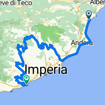
Overview
About this route
Route based on the guide (cloned from route 3064866)
- -:--
- Duration
- 166.6 km
- Distance
- 2,754 m
- Ascent
- 2,764 m
- Descent
- ---
- Avg. speed
- ---
- Max. altitude

Route quality
Waytypes & surfaces along the route
Waytypes
Quiet road
25 km
(15 %)
Road
6.7 km
(4 %)
Surfaces
Paved
30 km
(18 %)
Unpaved
3.3 km
(2 %)
Asphalt
30 km
(18 %)
Ground
3.3 km
(2 %)
Undefined
133.3 km
(80 %)
Continue with Bikemap
Use, edit, or download this cycling route
You would like to ride Alpy Liguryjskie or customize it for your own trip? Here is what you can do with this Bikemap route:
Free features
- Save this route as favorite or in collections
- Copy & plan your own version of this route
- Split it into stages to create a multi-day tour
- Sync your route with Garmin or Wahoo
Premium features
Free trial for 3 days, or one-time payment. More about Bikemap Premium.
- Navigate this route on iOS & Android
- Export a GPX / KML file of this route
- Create your custom printout (try it for free)
- Download this route for offline navigation
Discover more Premium features.
Get Bikemap PremiumFrom our community
Other popular routes starting in Alassio
 Alassio - Moglio
- Distance
- 14 km
- Ascent
- 498 m
- Descent
- 496 m
- Location
- Alassio, Liguria, Italy
 Alassio-Ceriale-Alassio
- Distance
- 41.2 km
- Ascent
- 424 m
- Descent
- 425 m
- Location
- Alassio, Liguria, Italy
 Da Via Neghelli, Alassio a Via Neghelli, Alassio
- Distance
- 5,471.9 km
- Ascent
- 16,655 m
- Descent
- 16,657 m
- Location
- Alassio, Liguria, Italy
 Granfondo di Alassio
- Distance
- 105.9 km
- Ascent
- 1,979 m
- Descent
- 1,410 m
- Location
- Alassio, Liguria, Italy
 ALBENGA-ALBENGA
- Distance
- 109.1 km
- Ascent
- 2,051 m
- Descent
- 2,049 m
- Location
- Alassio, Liguria, Italy
 Varie Salite
- Distance
- 86.3 km
- Ascent
- 1,850 m
- Descent
- 1,865 m
- Location
- Alassio, Liguria, Italy
 Randonnée del Muretto di Alassio 2023 !!!!-16069481
- Distance
- 191.1 km
- Ascent
- 2,706 m
- Descent
- 2,704 m
- Location
- Alassio, Liguria, Italy
 De Via Privata Londra 54, Alassio à Via Francesco Maria Giancardi 33/A, Alassio
- Distance
- 4.7 km
- Ascent
- 44 m
- Descent
- 63 m
- Location
- Alassio, Liguria, Italy
Open it in the app