

Défi-Vélomag
A cycling route starting in Saint-Tite, Quebec, Canada.
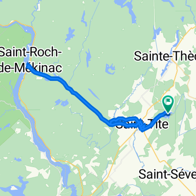
Overview
About this route
- -:--
- Duration
- 105.1 km
- Distance
- 977 m
- Ascent
- 977 m
- Descent
- ---
- Avg. speed
- ---
- Max. altitude
Continue with Bikemap
Use, edit, or download this cycling route
You would like to ride Défi-Vélomag or customize it for your own trip? Here is what you can do with this Bikemap route:
Free features
- Save this route as favorite or in collections
- Copy & plan your own version of this route
- Split it into stages to create a multi-day tour
- Sync your route with Garmin or Wahoo
Premium features
Free trial for 3 days, or one-time payment. More about Bikemap Premium.
- Navigate this route on iOS & Android
- Export a GPX / KML file of this route
- Create your custom printout (try it for free)
- Download this route for offline navigation
Discover more Premium features.
Get Bikemap PremiumFrom our community
Other popular routes starting in Saint-Tite
 St-Tite, Lac-aux-Sables
- Distance
- 37.7 km
- Ascent
- 212 m
- Descent
- 177 m
- Location
- Saint-Tite, Quebec, Canada
 Parc St-Jean - St-Mathieu
- Distance
- 59.2 km
- Ascent
- 1,111 m
- Descent
- 1,031 m
- Location
- Saint-Tite, Quebec, Canada
 St-Tite_Long du St-Maurice
- Distance
- 65.3 km
- Ascent
- 220 m
- Descent
- 220 m
- Location
- Saint-Tite, Quebec, Canada
 Parc St-Jean - Centenaire
- Distance
- 25.7 km
- Ascent
- 182 m
- Descent
- 192 m
- Location
- Saint-Tite, Quebec, Canada
 410 Ch de l'Île, St-Tite à 410 Ch de l'Île, St-Tite
- Distance
- 53.5 km
- Ascent
- 530 m
- Descent
- 532 m
- Location
- Saint-Tite, Quebec, Canada
 (6) Saint Jean de Piles-Saint Donat de Montcalm
- Distance
- 200.9 km
- Ascent
- 752 m
- Descent
- 458 m
- Location
- Saint-Tite, Quebec, Canada
 Défi Vélo Mag Parc de la Mauricie
- Distance
- 106.8 km
- Ascent
- 1,027 m
- Descent
- 1,027 m
- Location
- Saint-Tite, Quebec, Canada
 Parc de la Mauricie
- Distance
- 58.1 km
- Ascent
- 696 m
- Descent
- 576 m
- Location
- Saint-Tite, Quebec, Canada
Open it in the app