

ampe track
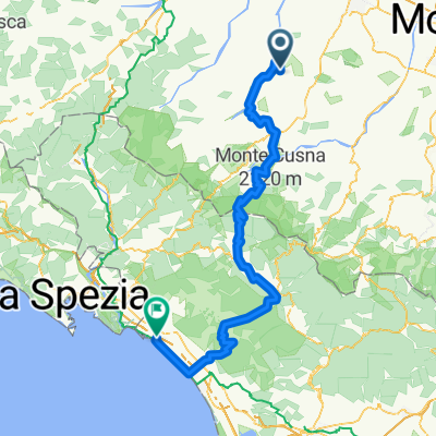
A cycling route starting in Ciano d'Enza, Emilia-Romagna, Italy.
Overview
About this route
test
- -:--
- Duration
- 33.8 km
- Distance
- 831 m
- Ascent
- 822 m
- Descent
- ---
- Avg. speed
- ---
- Max. altitude

Route quality
Waytypes & surfaces along the route
Waytypes
Quiet road
11.8 km
(35 %)
Busy road
9.9 km
(29 %)
Surfaces
Paved
13.7 km
(40 %)
Unpaved
3.7 km
(11 %)
Asphalt
13.7 km
(40 %)
Gravel
2.1 km
(6 %)
Continue with Bikemap
Use, edit, or download this cycling route
You would like to ride ampe track or customize it for your own trip? Here is what you can do with this Bikemap route:
Free features
- Save this route as favorite or in collections
- Copy & plan your own version of this route
- Sync your route with Garmin or Wahoo
Premium features
Free trial for 3 days, or one-time payment. More about Bikemap Premium.
- Navigate this route on iOS & Android
- Export a GPX / KML file of this route
- Create your custom printout (try it for free)
- Download this route for offline navigation
Discover more Premium features.
Get Bikemap PremiumFrom our community
Other popular routes starting in Ciano d'Enza
 Easy 50 Km
- Distance
- 51.4 km
- Ascent
- 211 m
- Descent
- 210 m
- Location
- Ciano d'Enza, Emilia-Romagna, Italy
 CanoCa - Canossa Carrara 2018
- Distance
- 155 km
- Ascent
- 2,388 m
- Descent
- 2,836 m
- Location
- Ciano d'Enza, Emilia-Romagna, Italy
 Salita dei Castelli
- Distance
- 7.4 km
- Ascent
- 446 m
- Descent
- 157 m
- Location
- Ciano d'Enza, Emilia-Romagna, Italy
 Grassano-Barcaccia
- Distance
- 12.3 km
- Ascent
- 155 m
- Descent
- 528 m
- Location
- Ciano d'Enza, Emilia-Romagna, Italy
 Coste di Bazzano
- Distance
- 5.8 km
- Ascent
- 314 m
- Descent
- 33 m
- Location
- Ciano d'Enza, Emilia-Romagna, Italy
 ampe track
- Distance
- 33.8 km
- Ascent
- 831 m
- Descent
- 822 m
- Location
- Ciano d'Enza, Emilia-Romagna, Italy
 ciano monte duro
- Distance
- 39.4 km
- Ascent
- 1,445 m
- Descent
- 1,157 m
- Location
- Ciano d'Enza, Emilia-Romagna, Italy
 Roncaglio, Bazzano, Neviano
- Distance
- 54.1 km
- Ascent
- 939 m
- Descent
- 939 m
- Location
- Ciano d'Enza, Emilia-Romagna, Italy
Open it in the app