

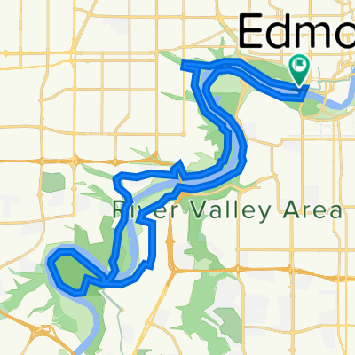
downtown and some river valley
A cycling route starting in Edmonton, Alberta, Canada.
Overview
About this route
just a portion of the many kilometres of river valley cycling.
- -:--
- Duration
- 32.2 km
- Distance
- 260 m
- Ascent
- 271 m
- Descent
- ---
- Avg. speed
- ---
- Max. altitude

Route quality
Waytypes & surfaces along the route
Waytypes
Cycleway
17.7 km
(55 %)
Path
7.1 km
(22 %)
Surfaces
Paved
27.7 km
(86 %)
Unpaved
2.6 km
(8 %)
Paved (undefined)
14.5 km
(45 %)
Asphalt
10.9 km
(34 %)
Continue with Bikemap
Use, edit, or download this cycling route
You would like to ride downtown and some river valley or customize it for your own trip? Here is what you can do with this Bikemap route:
Free features
- Save this route as favorite or in collections
- Copy & plan your own version of this route
- Sync your route with Garmin or Wahoo
Premium features
Free trial for 3 days, or one-time payment. More about Bikemap Premium.
- Navigate this route on iOS & Android
- Export a GPX / KML file of this route
- Create your custom printout (try it for free)
- Download this route for offline navigation
Discover more Premium features.
Get Bikemap PremiumFrom our community
Other popular routes starting in Edmonton
 Pioneer cabin
- Distance
- 4.4 km
- Ascent
- 171 m
- Descent
- 170 m
- Location
- Edmonton, Alberta, Canada
 Edmonton - Sherwood Park
- Distance
- 21.8 km
- Ascent
- 164 m
- Descent
- 138 m
- Location
- Edmonton, Alberta, Canada
 South West of Edmonton - Rabbit Hills Cycle out of city
- Distance
- 48.9 km
- Ascent
- 104 m
- Descent
- 105 m
- Location
- Edmonton, Alberta, Canada
 Edmonton River Valley SW 34k
- Distance
- 34.3 km
- Ascent
- 394 m
- Descent
- 393 m
- Location
- Edmonton, Alberta, Canada
 Relaxed route in Edmonton
- Distance
- 19.1 km
- Ascent
- 1,710 m
- Descent
- 1,712 m
- Location
- Edmonton, Alberta, Canada
 River Valley NE from Mill Creek
- Distance
- 33.8 km
- Ascent
- 220 m
- Descent
- 220 m
- Location
- Edmonton, Alberta, Canada
 Fer Rundle
- Distance
- 38.3 km
- Ascent
- 447 m
- Descent
- 447 m
- Location
- Edmonton, Alberta, Canada
 Terwillegar loop 01
- Distance
- 14.3 km
- Ascent
- 191 m
- Descent
- 194 m
- Location
- Edmonton, Alberta, Canada
Open it in the app