

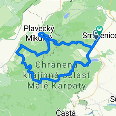
Doľany - Orešany a lesom
A cycling route starting in Smolenice, Trnava Region, Slovakia.
Overview
About this route
Malokarpatská
- -:--
- Duration
- 23.7 km
- Distance
- 384 m
- Ascent
- 384 m
- Descent
- ---
- Avg. speed
- ---
- Max. altitude

Route quality
Waytypes & surfaces along the route
Waytypes
Track
13.5 km
(57 %)
Road
4 km
(17 %)
Surfaces
Paved
16.8 km
(71 %)
Unpaved
5.9 km
(25 %)
Asphalt
16.8 km
(71 %)
Unpaved (undefined)
2.8 km
(12 %)
Route highlights
Points of interest along the route

Point of interest after 3.1 km

Point of interest after 3.2 km

Point of interest after 5.3 km

Point of interest after 5.4 km

Point of interest after 5.4 km

Point of interest after 5.5 km

Point of interest after 5.6 km

Point of interest after 5.8 km

Point of interest after 6.1 km

Point of interest after 7.3 km

Point of interest after 7.3 km

Point of interest after 8.1 km

Point of interest after 9.4 km

Point of interest after 10.6 km

Point of interest after 11 km

Point of interest after 12.1 km

Point of interest after 12.9 km

Point of interest after 13.2 km

Point of interest after 13.2 km

Point of interest after 13.2 km

Point of interest after 14 km

Point of interest after 15.9 km

Point of interest after 16.6 km

Point of interest after 16.7 km

Point of interest after 17.5 km

Point of interest after 18 km

Point of interest after 18.8 km

Point of interest after 19 km

Point of interest after 22.8 km

Point of interest after 23.3 km

Point of interest after 23.6 km
Continue with Bikemap
Use, edit, or download this cycling route
You would like to ride Doľany - Orešany a lesom or customize it for your own trip? Here is what you can do with this Bikemap route:
Free features
- Save this route as favorite or in collections
- Copy & plan your own version of this route
- Sync your route with Garmin or Wahoo
Premium features
Free trial for 3 days, or one-time payment. More about Bikemap Premium.
- Navigate this route on iOS & Android
- Export a GPX / KML file of this route
- Create your custom printout (try it for free)
- Download this route for offline navigation
Discover more Premium features.
Get Bikemap PremiumFrom our community
Other popular routes starting in Smolenice
 Recording from 8. 5. 2016, 12:30
- Distance
- 25.9 km
- Ascent
- 574 m
- Descent
- 589 m
- Location
- Smolenice, Trnava Region, Slovakia
 do školy ....ale len tak
- Distance
- 41.7 km
- Ascent
- 263 m
- Descent
- 267 m
- Location
- Smolenice, Trnava Region, Slovakia
 Katarinka parkovisko, Katarinka klastor, Dobra voda restauracia, Katarinka Parkovisko
- Distance
- 17.4 km
- Ascent
- 347 m
- Descent
- 350 m
- Location
- Smolenice, Trnava Region, Slovakia
 Jahodnícka 26, Smolenice do Jahodnícka 24, Smolenice
- Distance
- 6.3 km
- Ascent
- 147 m
- Descent
- 141 m
- Location
- Smolenice, Trnava Region, Slovakia
 Smolenice - Buková - Trstín - Smolenice
- Distance
- 34.5 km
- Ascent
- 499 m
- Descent
- 502 m
- Location
- Smolenice, Trnava Region, Slovakia
 Doľany - Orešany a lesom
- Distance
- 23.7 km
- Ascent
- 384 m
- Descent
- 384 m
- Location
- Smolenice, Trnava Region, Slovakia
 Malé Karpaty - Vápenná, Klokoč, Báborská,
- Distance
- 13.8 km
- Ascent
- 609 m
- Descent
- 609 m
- Location
- Smolenice, Trnava Region, Slovakia
 Náročná
- Distance
- 48.7 km
- Ascent
- 1,358 m
- Descent
- 1,352 m
- Location
- Smolenice, Trnava Region, Slovakia
Open it in the app