

zone a
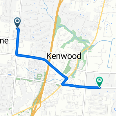
A cycling route starting in Rossmoyne, Ohio, United States.
Overview
About this route
6/6/15, 11:28 AM
- -:--
- Duration
- 9.7 km
- Distance
- 30 m
- Ascent
- 32 m
- Descent
- ---
- Avg. speed
- ---
- Max. altitude
Route quality
Waytypes & surfaces along the route
Waytypes
Quiet road
4.9 km
(51 %)
Road
0.6 km
(6 %)
Surfaces
Paved
0.3 km
(3 %)
Asphalt
0.3 km
(3 %)
Undefined
9.4 km
(97 %)
Continue with Bikemap
Use, edit, or download this cycling route
You would like to ride zone a or customize it for your own trip? Here is what you can do with this Bikemap route:
Free features
- Save this route as favorite or in collections
- Copy & plan your own version of this route
- Sync your route with Garmin or Wahoo
Premium features
Free trial for 3 days, or one-time payment. More about Bikemap Premium.
- Navigate this route on iOS & Android
- Export a GPX / KML file of this route
- Create your custom printout (try it for free)
- Download this route for offline navigation
Discover more Premium features.
Get Bikemap PremiumFrom our community
Other popular routes starting in Rossmoyne
 BikeComputer Training Session
- Distance
- 13 km
- Ascent
- 49 m
- Descent
- 51 m
- Location
- Rossmoyne, Ohio, United States
 zone a
- Distance
- 9.7 km
- Ascent
- 30 m
- Descent
- 32 m
- Location
- Rossmoyne, Ohio, United States
 Plainfield-BlueAsh Route
- Distance
- 16.1 km
- Ascent
- 59 m
- Descent
- 59 m
- Location
- Rossmoyne, Ohio, United States
 b
b- Distance
- 5 km
- Ascent
- 17 m
- Descent
- 16 m
- Location
- Rossmoyne, Ohio, United States
 june24
- Distance
- 16.7 km
- Ascent
- 54 m
- Descent
- 53 m
- Location
- Rossmoyne, Ohio, United States
 kenwwod
- Distance
- 2.9 km
- Ascent
- 32 m
- Descent
- 36 m
- Location
- Rossmoyne, Ohio, United States
 080314
- Distance
- 23.2 km
- Ascent
- 172 m
- Descent
- 172 m
- Location
- Rossmoyne, Ohio, United States
 090114
- Distance
- 23.1 km
- Ascent
- 182 m
- Descent
- 182 m
- Location
- Rossmoyne, Ohio, United States
Open it in the app