

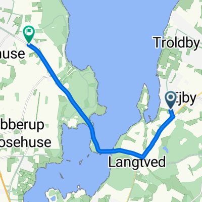
Munkholmbroen HFC 2/3
A cycling route starting in Ejby, Region Zealand, Denmark.
Overview
About this route
Den korte tur tilbage fra Munkholmbroen, hvis man ikke vil køre retur ad samme rute.
- -:--
- Duration
- 9.4 km
- Distance
- 72 m
- Ascent
- 68 m
- Descent
- ---
- Avg. speed
- ---
- Max. altitude
Route quality
Waytypes & surfaces along the route
Waytypes
Quiet road
6 km
(64 %)
Road
2.3 km
(24 %)
Surfaces
Paved
7.2 km
(77 %)
Unpaved
2.2 km
(23 %)
Asphalt
7.2 km
(77 %)
Gravel
1.4 km
(15 %)
Unpaved (undefined)
0.8 km
(8 %)
Continue with Bikemap
Use, edit, or download this cycling route
You would like to ride Munkholmbroen HFC 2/3 or customize it for your own trip? Here is what you can do with this Bikemap route:
Free features
- Save this route as favorite or in collections
- Copy & plan your own version of this route
- Sync your route with Garmin or Wahoo
Premium features
Free trial for 3 days, or one-time payment. More about Bikemap Premium.
- Navigate this route on iOS & Android
- Export a GPX / KML file of this route
- Create your custom printout (try it for free)
- Download this route for offline navigation
Discover more Premium features.
Get Bikemap PremiumFrom our community
Other popular routes starting in Ejby
 Ostsee 9a: Kirke Sonnerup-Slagelse 70,6km 280hm
- Distance
- 70.6 km
- Ascent
- 370 m
- Descent
- 368 m
- Location
- Ejby, Region Zealand, Denmark
 Lang tur
- Distance
- 206.3 km
- Ascent
- 324 m
- Descent
- 326 m
- Location
- Ejby, Region Zealand, Denmark
 Munkholmbroen HFC 2/3
- Distance
- 9.4 km
- Ascent
- 72 m
- Descent
- 68 m
- Location
- Ejby, Region Zealand, Denmark
 Ejby Strandvej, Kirke-Hyllinge to Jeppes Torp, Holbæk
- Distance
- 7.5 km
- Ascent
- 37 m
- Descent
- 37 m
- Location
- Ejby, Region Zealand, Denmark
 Min normale cykelrute
- Distance
- 9.5 km
- Ascent
- 51 m
- Descent
- 52 m
- Location
- Ejby, Region Zealand, Denmark
 Østre Færgevej 68, Holbæk to Salvigvej 3, Holbæk
- Distance
- 11.7 km
- Ascent
- 92 m
- Descent
- 90 m
- Location
- Ejby, Region Zealand, Denmark
 Windy route with hills
- Distance
- 3.7 km
- Ascent
- 13 m
- Descent
- 10 m
- Location
- Ejby, Region Zealand, Denmark
 Camping to Arken
- Distance
- 44.6 km
- Ascent
- 153 m
- Descent
- 157 m
- Location
- Ejby, Region Zealand, Denmark
Open it in the app