

Franky´s Rhein-Kanal-Runde 2
A cycling route starting in Kamp-Lintfort, North Rhine-Westphalia, Germany.
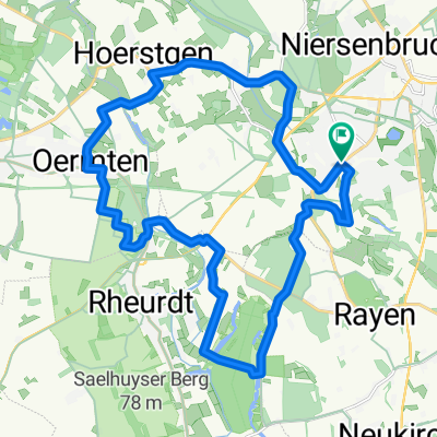
Overview
About this route
<p>Pattberg, Baerl, Homberg, A40 Rhine Bridge, Kasslerfeld, Pontwert, Rhine-Herne Canal, Kaisergarten, Centro, Emscherweg, Hoagweg, Landschaftspark Duisburg Nord, Meiderich, Ruhrort, Mühlenweide, Laar, Beekerwerth, Alsum spoil heap, Walsum Rhine Ferry, Orsoy, Eversal, Budberg, Rheinkamp railway station, Pattberg.</p>
Translated, show original (German)- -:--
- Duration
- 81.4 km
- Distance
- 101 m
- Ascent
- 99 m
- Descent
- ---
- Avg. speed
- ---
- Max. altitude

Continue with Bikemap
Use, edit, or download this cycling route
You would like to ride Franky´s Rhein-Kanal-Runde 2 or customize it for your own trip? Here is what you can do with this Bikemap route:
Free features
- Save this route as favorite or in collections
- Copy & plan your own version of this route
- Split it into stages to create a multi-day tour
- Sync your route with Garmin or Wahoo
Premium features
Free trial for 3 days, or one-time payment. More about Bikemap Premium.
- Navigate this route on iOS & Android
- Export a GPX / KML file of this route
- Create your custom printout (try it for free)
- Download this route for offline navigation
Discover more Premium features.
Get Bikemap PremiumFrom our community
Other popular routes starting in Kamp-Lintfort
 Lintfort-Tour by O.Broll
- Distance
- 24.8 km
- Ascent
- 32 m
- Descent
- 27 m
- Location
- Kamp-Lintfort, North Rhine-Westphalia, Germany
 le tour de Kamp-Lintfort
- Distance
- 17.7 km
- Ascent
- 33 m
- Descent
- 27 m
- Location
- Kamp-Lintfort, North Rhine-Westphalia, Germany
 Kamp-Lintfort-Kempen-Straelen-Kamp-Lintfort
- Distance
- 88.5 km
- Ascent
- 100 m
- Descent
- 100 m
- Location
- Kamp-Lintfort, North Rhine-Westphalia, Germany
 Die Leucht-Route
- Distance
- 24.8 km
- Ascent
- 101 m
- Descent
- 103 m
- Location
- Kamp-Lintfort, North Rhine-Westphalia, Germany
 Drei Haldentour
- Distance
- 35.7 km
- Ascent
- 221 m
- Descent
- 223 m
- Location
- Kamp-Lintfort, North Rhine-Westphalia, Germany
 Sakrale Bauten am Niederrhein
- Distance
- 63.5 km
- Ascent
- 124 m
- Descent
- 167 m
- Location
- Kamp-Lintfort, North Rhine-Westphalia, Germany
 Kamp-Lintfort-Kempen-Straelen-Kamp-Lintfort
- Distance
- 69.7 km
- Ascent
- 151 m
- Descent
- 152 m
- Location
- Kamp-Lintfort, North Rhine-Westphalia, Germany
 Lintfort - Oermter Berg - Lintfort
- Distance
- 23.3 km
- Ascent
- 86 m
- Descent
- 85 m
- Location
- Kamp-Lintfort, North Rhine-Westphalia, Germany
Open it in the app